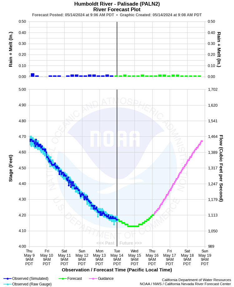
| HUMBOLDT RIVER - PALISADE (PALN2) | ||
| Latitude: 40.61º N | Longitude: 116.20º W | Elevation: 4826 Feet |
| Location: Eureka County in NV | ||
| River Group: Humboldt | ||
| Forecast Issued: | Apr 24 2024 at 7:50 AM PDT | Next Issuance: | Apr 25 2024 at 9:00 AM PDT |
| Monitor Stage: 6.0 Feet | Flood Stage: 7.0 Feet |
Prev. Point | Next Point | Tabular |
Back to Points | Back to Home | Ensemble Fcst |
 |
Historical Stage/Flow Data |
|||
|
Water Year
|
Peak Discharge (cfs)
|
Stage (feet)
|
Date
|
| Most Recent 5 Years | |||
2022* |
336 |
2.55 |
Jun 1, 2022 |
2021* |
486 |
3.01 |
Jun 7, 2021 |
2020* |
538 |
3.18 |
May 23, 2020 |
2019* |
4,200 |
7.46 |
Jun 11, 2019 |
2018* |
1,080 |
4.25 |
Jun 1, 2018 |
| Historical High Stage/Flow Events (Period of Record - Jul 1911 to Present) - Ranked by Flow | |||
1984* |
7,870 |
10.08 |
May 18, 1984 |
1983* |
7,240 |
9.75 |
Mar 06, 1983 |
1962* |
6,610 |
10.00 |
Feb 12, 1962 |
2006* |
6,330 |
9.08 |
Apr 08, 2006 |
1952* |
6,050 |
9.53 |
May 02, 1952 |
| * Discharge affected to unknown degree by regulation or diversion | |||
| Location Photographs | ||
| ESRI™ Locator Map |
| Impacts - E19 Information | |
| 7.0 Feet | Flood Stage - Minor lowland flooding begins. |
| 7.5 Feet | Minor to moderate lowland flooding from Carlin to Battle Mountain. |
| 8.0 Feet | Moderate lowland flooding from Carlin to Battle Mountain. |
| 8.5 Feet | Significant lowland flooding with minor damage from Carlin to Battle Mountain. Some damage to low-lying structures. A few rural roads flood (similar to 06/1995 flood). |
| 9.0 Feet | Significant to major lowland flooding with moderate damage from Carlin to Battle Mountain. Moderate damage to low-lying structures, rural roads, and bridge. Ranch buildings and livestock affected. Erosion decrades ranch/farm land (similar to 01/1943, 05,1952, and 02/1986 floods). |
| 9.5 Feet | Major lowland flooding with significant damage to roads, railroads, and buildings along the river from Carlin to Battle Mountain. Lower portions of Carlin and Beowawe flood. Significant agricultural losses (livestock, irrigation structures, and erosion). USGS 25 year flood (similar to 02/1962 and 03/1983 floods). |
| 10.0 Feet | Major flood damage. Extensive damage to railroads, roads, bridges, buildings, irrigation structures, and ranch land. Heavy livestock losses. Total loss probably over $10 Million in reach. Many road closures in area (similar to 05/1984 flood - record since 1910). |
| 10.5 Feet | Disastrous flooding. Extensive damage throughout reach. Exceeds modern (05/1984) flood. USGS 50 year flood. |
| 12.0 Feet | Catastrophic flooding. USGS estimated 100 year flood. |
| 17.0 Feet | Record flood with widespread catastrophic damage. Like largest known flood (02/1910). Catastrophic damage to roads, bridges, railroads, and buildings. River becomes a large lake 4 to 5 miles wide from Beowawe to Battle Mountain. Transportation nearly impossible. Communications out to many areas. |