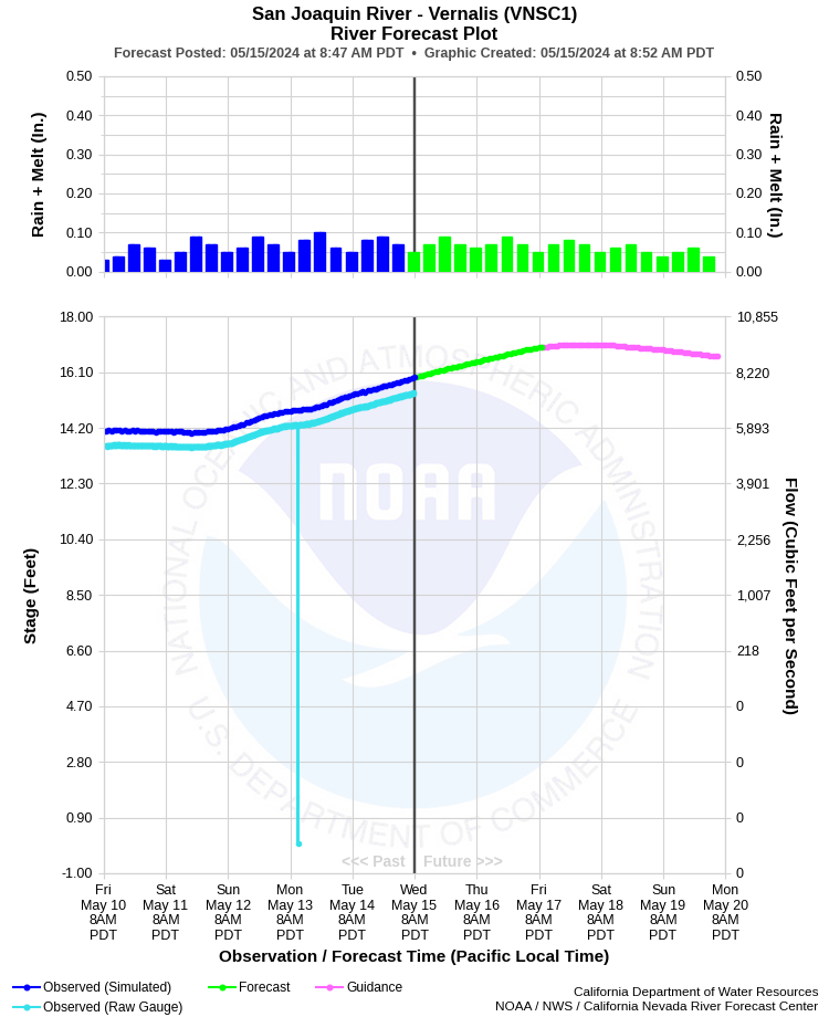
| SAN JOAQUIN RIVER - VERNALIS (VNSC1) | ||
| Latitude: 37.68º N | Longitude: 121.27º W | Elevation: 35 Feet |
| Location: San Joaquin County in CA | ||
| River Group: San Joaquin | ||
| Forecast Issued: | Apr 25 2024 at 8:44 AM PDT | Next Issuance: | Apr 26 2024 at 9:00 AM PDT |
| Monitor Stage: 24.5 Feet | Flood Stage: 29.0 Feet | Danger Stage: 29.5 Feet |
Prev. Point | Next Point | Tabular |
Back to Points | Back to Home | Ensemble Fcst |
 |
Historical Stage/Flow Data |
|||
|
Water Year
|
Peak Discharge (cfs)
|
Stage (feet)
|
Date
|
| Most Recent 5 Years | |||
2022* |
2,600 |
10.83 |
Dec 29, 2021 |
2021* |
2,470 |
10.76 |
Jan 31, 2021 |
2020* |
6,130 |
14.29 |
Dec 9, 2019 |
2019* |
17,200 |
21.82 |
Mar 13, 2019 |
2018* |
11,000 |
17.83 |
Apr 8, 2018 |
| Historical High Stage/Flow Events (Period of Record - Jul 1922 to Present) - Ranked by Flow | |||
1951* |
79,000 |
27.75 |
Dec 09, 1950 |
1997* |
75,600 |
34.88 |
Jan 05, 1997 |
1969* |
52,600 |
34.55 |
Jan 27, 1969 |
1938* |
51,200 |
26.64 |
Mar 16, 1938 |
1956* |
50,900 |
26.89 |
Dec 25, 1955 |
1983* |
45,100 |
31.49 |
Mar 07, 1983 |
| * Discharge affected by regulation or diversion | |||
| Location Photographs | ||
| ESRI™ Locator Map |
| Impacts - E19 Information | |
| 21.0 Feet | Seepage begins into crop area outside of levees. |
| 24.5 Feet | Monitor Stage. Water reaches the toe of levee. |
| 26.0 Feet | Severe seepage occurs outside the levees. The area covered by seepage will increase as the river stage rises. |
| 29.6 Feet | Homes along east bank of river on Airport Court in Manteca experience flooding. |
| 37.3 Feet | Stages above 37.3 Feet results in flooding outside the levees. Top of levee. |