
| Back to Obs Reservoir Map | <<< Previous Reservoir | | | Next Reservoir >>> | Printer Version |
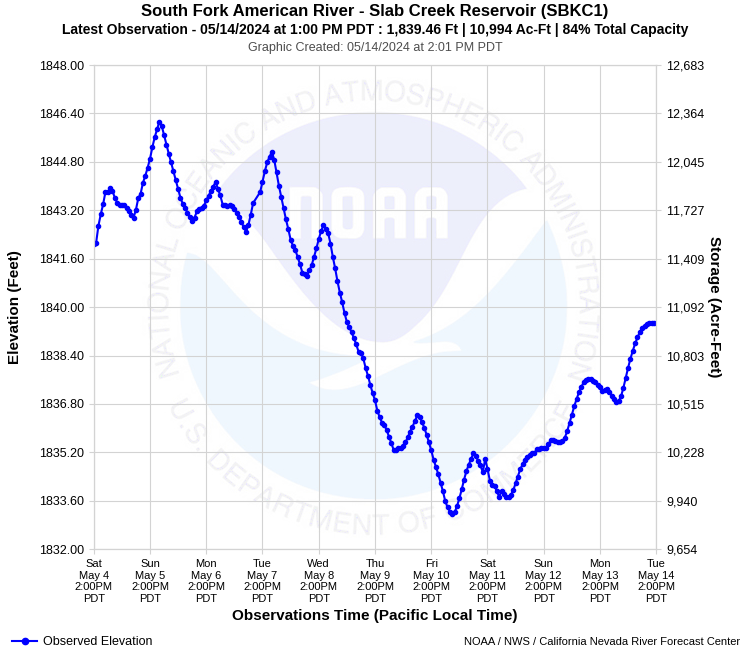
| Latitude: 38.77º N | Longitude: 120.70º W | Elevation: 1850 Feet | |
| Location: El Dorado County in California | River Group: Lower Sacramento | ||
| Monitor Stage: N/A | Flood Stage: N/A |
| ESRI™ Locator Map |
| Official 7 Day National Weather Service Forecast (CAZ067) |
| Today: Mostly cloudy. Highs 58 to 70. Prevailing west winds up to 10 mph. Tonight: Mostly clear. Lows 42 to 48. Prevailing west winds up to 10 mph in the evening becoming light. Thursday: Mostly sunny in the morning then becoming mostly cloudy. Highs 58 to 68. Prevailing south winds up to 15 mph. Thursday Night: Mostly cloudy with a chance of rain showers. Lows 43 to 51. Prevailing southwest winds up to 15 mph. Friday: Mostly cloudy. A chance of rain showers in the morning, then a chance of rain showers and a slight chance of thunderstorms in the afternoon. Highs 52 to 66. Prevailing southwest winds up to 10 mph. Friday Night: Mostly clear. Lows 38 to 46. Saturday: Sunny, warmer. Highs 60 to 70. Saturday Night: Mostly clear. Lows 42 to 48. Sunday through Tuesday: Clear. Highs 63 to 75. Lows 42 to 51. |
| Product Disclaimer |
This river graphic is not intended to serve as a substitute for official flood watches, warnings, advisories, or statements issued by the NWS Sacramento Weather Forecast Office. Observations are preliminary and subject to change. River levels identified as "forecast" should be consistent with those contained in official NWS products. River levels identified as "guidance" have significant uncertainty due to future weather or reservoir regulation and are provided for planning purposes only. |