CNRFC Mobile Logo


CNRFC Daily Briefing
Last issued: Thu Jan 01, 2026 at 09:56 AM PST (updated daily by 10 AM Pacific Time).
Click image for full-resolution version.
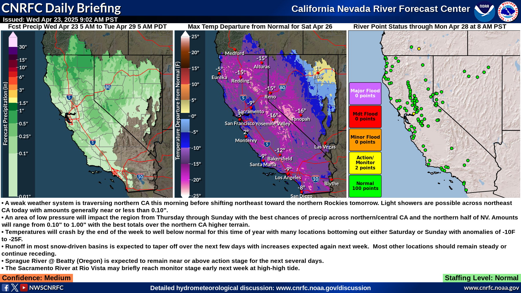


Summary:
  • Heavier precipitation over coastal southern CA early this morning before diminishing and becoming more scattered in the afternoon.
  • Thunderstorm chances the next few afternoons, best probabilities over coastal srn CA today and over the Sacramento Valley to the north coast on Saturday.
  • Wet pattern continues the rest of the forecast period as additional systems move in from the Gulf of Alaska.
  • Increased flow along the Sacramento system will allow weirs to continue or begin to flow this weekend.
  • Moderate streamflow increases over the next few days will allow many locations to exceed monitor/action stage.
  • San Diego River at Fashion Valley is currently above minor flood stage due to heavy rainfall this morning.
Confidence: Moderate, Low Sunday Onward

Staffing Level: Normal

Detailed Hydrometeorological Discussion: www.cnrfc.noaa.gov/discussion

River Guidance Forecast Critical Stage Exceedance
ID River / Creek Gage / Station Forecast Status

ARCC1

MAD ARCATA Above Action/Monitor

FRNC1

EEL FERNBRIDGE Above Action/Monitor

TEHC1

SACRAMENTO TEHAMA BRIDGE Above Action/Monitor

ORFC1

SACRAMENTO ORD FERRY Above Action/Monitor

CLAC1

SACRAMENTO COLUSA WEIR Above Action/Monitor

CLUC1

SACRAMENTO COLUSA BRIDGE Above Action/Monitor

TISC1

SACRAMENTO TISDALE WEIR Above Action/Monitor

FMWC1

SACRAMENTO FREMONT WEIR Above Action/Monitor

RVBC1

SACRAMENTO RIO VISTA Above Action/Monitor

MFTC1

MIDDLE FORK FEATHER PORTOLA Above Action/Monitor

LSBC1

YOLO BYPASS LISBON Above Action/Monitor

MHBC1

COSUMNES MICHIGAN BAR Above Action/Monitor

MCNC1

COSUMNES MCCONNELL Above Action/Monitor

SUSC1

SUSAN SUSANVILLE Above Action/Monitor

Select ID from list above to view graphical river forecast.