
| ||||||||||||||||||
| CANYON CREEK - BOWMAN RESERVOIR (BWKC1) | ||||||||||||||||||
| Latitude: 39.45º N | Longitude: 120.65º W | Elevation: 5575 Feet | ||||||||||||||||
| Location: Nevada County in CA | ||||||||||||||||||
| River Group: Lower Sacramento | ||||||||||||||||||
| Issuance Time: | Jul 06 2025 at 7:51 AM PDT |
| Please Note: | Ensemble forecasts produced by CNRFC only consider meteorological uncertainty and do not account for hydrologic uncertainty. Flow data on this product are unregulated / full natural flow. |
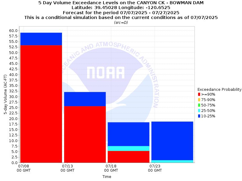
| 4x5-Day Probability Plot |
| Location Photographs | ||
| ESRI™ Locator Map |
| Official 7 Day National Weather Service Forecast (CAZ069) |
| Tonight: Clear. At higher elevations, a slight chance of rain showers early in the evening. Lows 46 to 61 higher elevations and 55 to 69 lower elevations. Prevailing west winds up to 10 mph in the evening becoming light. Monday: Sunny. Highs 69 to 84 higher elevations and 80 to 90 lower elevations. Light winds becoming southwest up to 10 mph in the afternoon. Monday Night: Clear. Lows 45 to 60 higher elevations and 55 to 67 lower elevations. Prevailing southwest winds up to 10 mph in the evening becoming light. Tuesday: Sunny. Highs 66 to 81 higher elevations and 77 to 87 lower elevations. Light winds becoming southwest up to 10 mph in the afternoon. Tuesday Night: Clear. Lows 43 to 58 higher elevations and 53 to 67 lower elevations. Prevailing southwest winds up to 10 mph with gusts to around 25 mph in the evening becoming light. Wednesday: Sunny. Highs 70 to 85. Wednesday Night: Clear. Lows 49 to 64. Thursday through Sunday: Clear. Highs 77 to 92. Lows 51 to 66. |