
| ||||||||||||||||||
| BEAR RIVER - CAMP FAR WEST RESERVOIR (CFWC1) | ||||||||||||||||||
| Latitude: 39.05º N | Longitude: 121.31º W | Elevation: 260 Feet | ||||||||||||||||
| Location: Yuba County in CA | ||||||||||||||||||
| River Group: Lower Sacramento | ||||||||||||||||||
| Issuance Time: | Jul 06 2025 at 7:51 AM PDT |
| Please Note: | Ensemble forecasts produced by CNRFC only consider meteorological uncertainty and do not account for hydrologic uncertainty. |
| 10-Day Accumulated Volume Plot |
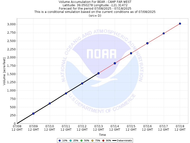
| Tabular 10-Day Streamflow Volume Accumulation (1000s of Acre-Feet) Data Updated: Jul 06 2025 at 7:58 AM PDT | ||||||||||
| Prob | Jul 07 | Jul 08 | Jul 09 | Jul 10 | Jul 11 | |||||
| 10% (Max) | 0.3 | 0.6 | 0.9 | 1.2 | 1.5 | |||||
| 25% | 0.3 | 0.6 | 0.9 | 1.2 | 1.5 | |||||
| 50% (Prob) | 0.3 | 0.6 | 0.9 | 1.2 | 1.5 | |||||
| 75% | 0.3 | 0.6 | 0.9 | 1.2 | 1.5 | |||||
| 90% (Min) | 0.3 | 0.6 | 0.9 | 1.2 | 1.5 | |||||
| RFC FCST | 0.3 | 0.6 | 0.9 | 1.2 | 1.5 | |||||
| Prob | Jul 12 | Jul 13 | Jul 14 | Jul 15 | Jul 16 | |||||
| 10% (Max) | 1.8 | 2.1 | 2.4 | 2.7 | 3.0 | |||||
| 25% | 1.8 | 2.1 | 2.4 | 2.7 | 3.0 | |||||
| 50% (Prob) | 1.8 | 2.1 | 2.4 | 2.7 | 3.0 | |||||
| 75% | 1.8 | 2.1 | 2.4 | 2.7 | 3.0 | |||||
| 90% (Min) | 1.8 | 2.1 | 2.4 | 2.7 | 3.0 | |||||
| Location Photographs | ||
| ESRI™ Locator Map |
| Official 7 Day National Weather Service Forecast (CAZ016) |
| Today: Sunny. Highs around 95. Southeast winds up to 10 mph. Gusts up to 20 mph in the afternoon. Tonight: Clear. Lows 57 to 63. South winds up to 15 mph. Tuesday: Sunny. Highs around 90. Southeast winds up to 10 mph. Tuesday Night: Clear. Lows 57 to 63. South winds up to 10 mph with gusts to around 20 mph. Wednesday: Sunny. Highs around 93. Light winds. Wednesday Night: Clear. Lows 62 to 70. Thursday: Sunny. Highs around 101. Thursday Night through Sunday: Clear. Lows 63 to 73. Highs around 101. |