
| ||||||||||||||||||
| SMITH RIVER - DOCTOR FINE BRIDGE (FTDC1) | ||||||||||||||||||
| Latitude: 41.88º N | Longitude: 124.14º W | Elevation: 0 Feet | ||||||||||||||||
| Location: Del Norte County in CA | ||||||||||||||||||
| River Group: North Coast | ||||||||||||||||||
| Issuance Time: | Jul 06 2025 at 8:14 AM PDT |
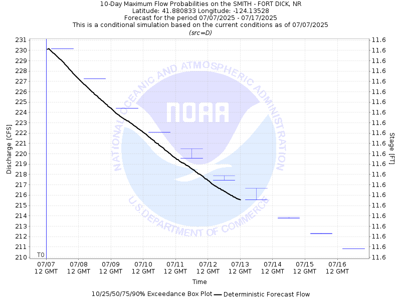
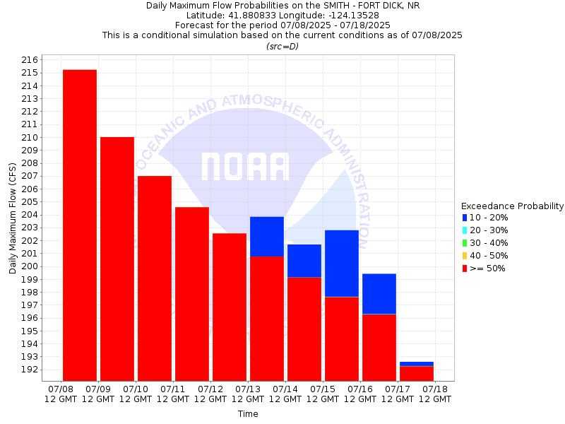
| Please Note: | Ensemble forecasts produced by CNRFC only consider meteorological uncertainty and do not account for hydrologic uncertainty. |
| 10-Day Probability Plot |
| Location Photographs | ||
| ESRI™ Locator Map |
| Official 7 Day National Weather Service Forecast (CAZ101) |
| Tonight: Mostly clear. Lows 50 to 60. Southwest wind around 5 mph shifting to the north overnight. Monday: Partly cloudy in the morning then clearing. Highs 64 to 78. Southwest wind around 5 mph. Monday Night: Partly cloudy in the evening then becoming mostly cloudy. Patchy fog overnight. Lows 47 to 57. Southwest wind around 5 mph in the evening becoming light. Tuesday: Mostly cloudy. Patchy fog. Highs 58 to 70. Southwest wind around 5 mph. Tuesday Night and Wednesday: Mostly cloudy. Patchy fog. Lows 47 to 57. Highs 58 to 73. Northwest wind around 10 mph. Wednesday Night and Thursday: Partly cloudy. Lows 50 to 60. Highs 66 to 81. Thursday Night: Mostly clear. Lows 51 to 61. Friday through Sunday: Partly cloudy. Highs 69 to 84. Lows 50 to 60. |
| Flood Impacts | |
| 40.0 Feet | Many roads and structures in the vicinity of the river are likely to be threatened. Significant flooding expected along US Highways 101 and 199, South Bank Rd, and in low lying areas between Lake Earl and the river, including areas along Lower Lake Drive. |
| 38.0 Feet | Expect flooding of portions of Highway 197 and South Bank Rd in the vicinity of US Highway 101. Flooding is also expected in low lying areas between Lake Earl and the river, including areas along Lower Lake Drive. Some access roads and homes in this area may be flooded. |
| 36.0 Feet | Flooding of South Bank Rd in the vicinity of US Highway 101 is likely. Water can flow across low-lying areas into Lake Earl about 4 miles south of the river, including areas along Lower Lake Drive. Some low-lying residential access roads may flood. |
| 33.0 Feet | Flooding is likely near the gravel plant and on South Bank Road in the vicinity of US Highway 101. Water may flow across low-lying areas into Lake Earl about 4 miles south of the river, including areas along lower Lake Drive. |
| 31.0 Feet | Minor flooding may occur around the gravel plant near US Highway 101 and South Bank Road approximately 1 mile upstream from Doctor Fine Bridge. |