
| ||||||||||||||||||
| TUOLUMNE RIVER - HETCH HETCHY RESERVOIR (HETC1) | ||||||||||||||||||
| Latitude: 37.95º N | Longitude: 119.79º W | Elevation: 3870 Feet | ||||||||||||||||
| Location: Tuolumne County in CA | ||||||||||||||||||
| River Group: San Joaquin | ||||||||||||||||||
| Issuance Time: | Jun 16 2025 at 6:20 AM PDT |
| Please Note: | Ensemble forecasts produced by CNRFC only consider meteorological uncertainty and do not account for hydrologic uncertainty. Flow data on this product are unregulated / full natural flow. |
| Monthly Probability Plot |
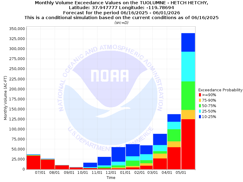
| Monthly Streamflow Volume (1000s of Acre-Feet) Data Updated: Jun 16 2025 at 6:28 AM PDT | ||||||
| Prob | Jun* | Jul | Aug | Sep | Oct | Nov |
| 10% | 118.3 | 26.1 | 10.1 | 5.3 | 16.2 | 30.8 |
| 25% | 117.4 | 25.2 | 9.9 | 4.7 | 5.1 | 9.5 |
| 50% | 116.6 | 24.6 | 9.8 | 4.4 | 2.8 | 5.7 |
| 75% | 115.9 | 24.2 | 9.7 | 4.3 | 2.6 | 2.2 |
| 90% | 114.9 | 23.6 | 9.5 | 4.2 | 2.4 | 1.6 |
| Mean | 199.0 | 82.4 | 15.3 | 5.3 | 9.0 | 14.0 |
| %Mean | 58.6 | 29.9 | 64.1 | 83.0 | 31.1 | 40.7 |
| Prob | Dec | Jan | Feb | Mar | Apr | May |
| 10% | 55.1 | 62.4 | 59.6 | 88.2 | 137.1 | 339.1 |
| 25% | 18.9 | 32.3 | 37.4 | 60.2 | 118.0 | 292.7 |
| 50% | 9.5 | 21.2 | 22.5 | 44.8 | 99.8 | 218.7 |
| 75% | 4.4 | 7.8 | 14.8 | 38.8 | 69.4 | 147.5 |
| 90% | 1.7 | 4.5 | 8.6 | 26.7 | 54.7 | 124.7 |
| Mean | 20.6 | 29.3 | 29.5 | 50.1 | 103.4 | 219.7 |
| %Mean | 46.1 | 72.4 | 76.3 | 89.4 | 96.5 | 99.5 |
| Note 1: %Mean is the "Median forecast monthly value (50%)" divided by the "monthly mean" (displayed as a %) | ||||||
| Note 2: For current month, graphic represents remaining forecast only, text represents observed + remaining forecast. | ||||||
| Location Photographs | ||
| ESRI™ Locator Map |
| Official 7 Day National Weather Service Forecast (CAZ323) |
| Tonight: Colder, clear. Lows 29 to 41. Southwest winds 10 to 15 mph with gusts to around 45 mph shifting to the south with gusts to around 30 mph after midnight. Saturday: Sunny. Highs 43 to 57. West winds 5 to 15 mph with gusts to around 40 mph. Saturday Night: Colder. Mostly clear. Lows 25 to 41. Northwest winds 5 to 15 mph with gusts to around 30 mph shifting to the northeast 5 to 10 mph after midnight. Sunday: Not as cool. Sunny. Highs 52 to 64. South winds up to 5 mph shifting to the southwest 5 to 15 mph in the afternoon. Sunday Night: Mostly clear. Lows 30 to 46. West winds 5 to 10 mph shifting to the northeast after midnight. Monday through Tuesday Night: Mostly clear. Highs 53 to 71. Lows 34 to 53. Wednesday through Thursday: Clear. Highs 62 to 78. Lows 39 to 55. Thursday Night: Mostly clear. Lows 41 to 55. Friday: Sunny. Highs 64 to 78. |