
| ||||||||||||||||||
| MERCED RIVER - HAPPY ISLES (HPIC1) | ||||||||||||||||||
| Latitude: 37.73º N | Longitude: 119.56º W | Elevation: 4017 Feet | ||||||||||||||||
| Location: Mariposa County in CA | ||||||||||||||||||
| River Group: San Joaquin | ||||||||||||||||||
| Issuance Time: | Jul 06 2025 at 8:12 AM PDT |
| Please Note: | Ensemble forecasts produced by CNRFC only consider meteorological uncertainty and do not account for hydrologic uncertainty. |
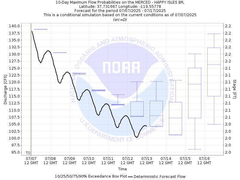
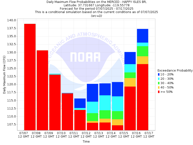
| 10-Day Probability Plot |
| Location Photographs | ||
| ESRI™ Locator Map |
| Official 7 Day National Weather Service Forecast (CAZ324) |
| Today: Sunny. Highs 78 to 92. West winds up to 5 mph increasing to southwest 10 to 15 mph in the afternoon. Tonight: Clear. Lows 56 to 64. South winds 5 to 10 mph shifting to the east after midnight. Tuesday: Sunny. Highs 77 to 91. Southeast winds up to 10 mph shifting to the southwest in the afternoon. Tuesday Night: Clear. Lows 56 to 64. Southwest winds 5 to 10 mph shifting to the east after midnight. Wednesday: Sunny. Highs 77 to 91. Southeast winds up to 5 mph increasing to southwest 10 to 15 mph in the afternoon. Wednesday Night through Sunday: Clear. Lows 57 to 70. Highs 81 to 98. |
| Flood Impacts | |
| 13.27 Feet | Flood of Record: 1/2/97. $178 million in damage to Yosemite Valley. |
| 10.0 Feet | Northside Drive at Wosky Pond, Southside Drive at Chapel Meadow, El Capitan crossover, and Sentinel crossover are impassable to vehicles. |
| 8.2 Feet | Swinging Bridge overtops. Water on road at Northside Drive, Southsie Drive, El Capitan crossover, and Sentinel crossover. |
| 7.5 Feet | Flood Stage. Housekeeping camp and Yosemite Valley backpacker campground begin to flood. |
| 7.0 Feet | North Pines and Lower Pines campgrounds begin flooding. |