
| ||||||||||||||||||
| MERCED RIVER - HAPPY ISLES (HPIC1) | ||||||||||||||||||
| Latitude: 37.73º N | Longitude: 119.56º W | Elevation: 4017 Feet | ||||||||||||||||
| Location: Mariposa County in CA | ||||||||||||||||||
| River Group: San Joaquin | ||||||||||||||||||
| Issuance Time: | Jun 25 2025 at 7:52 AM PDT |
| Please Note: | Ensemble forecasts produced by CNRFC only consider meteorological uncertainty and do not account for hydrologic uncertainty. Flow data on this product are unregulated / full natural flow. |
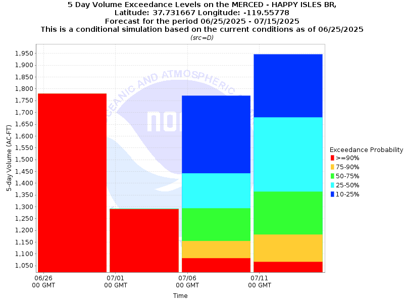
| 4x5-Day Probability Plot |
| Tabular 4 x 5-Day Streamflow Volume Data | |||||
| Observed Peak 1-Day Streamflow Volume: (April 1 at 12 UTC to Current Date at 12 UTC) | Observed 05/12/2025 4.1kaf | ||||
| Forecast Peak 1-Day Streamflow Volume: (Current Date at 12 UTC to August 1 at 12 UTC) | 10% (Max) 07/15/2025 1.0kaf | 25% 06/26/2025 0.4kaf | 50% (Prob) 06/26/2025 0.4kaf | 75% 06/26/2025 0.4kaf | 90% (Min) 06/26/2025 0.4kaf |
| Tabular 5-Day Volume Accumulations (1000s of Acre-Feet) | ||||
| Probability | 06/25 to 06/30 | 06/30 to 07/05 | 07/05 to 07/10 | 07/10 to 07/15 |
| 10% | 1.8 kaf | 1.3 kaf | 1.8 kaf | 1.9 kaf |
| 25% | 1.8 kaf | 1.3 kaf | 1.4 kaf | 1.7 kaf |
| 50% (Median) | 1.8 kaf | 1.3 kaf | 1.3 kaf | 1.4 kaf |
| 75% | 1.8 kaf | 1.3 kaf | 1.2 kaf | 1.2 kaf |
| 90% | 1.8 kaf | 1.3 kaf | 1.1 kaf | 1.1 kaf |
| Location Photographs | ||
| ESRI™ Locator Map |
| Official 7 Day National Weather Service Forecast (CAZ324) |
| Today: Sunny. Highs 75 to 87. East winds up to 5 mph shifting to the west 5 to 15 mph in the afternoon. Tonight: Clear. Lows 55 to 63. West winds 5 to 10 mph shifting to the east after midnight. Thursday: Sunny. Highs 77 to 89. Southeast winds up to 5 mph shifting to the southwest 5 to 15 mph in the afternoon. Thursday Night: Clear. Lows 56 to 64. West winds 5 to 10 mph shifting to the east after midnight. Friday: Sunny. Highs 78 to 90. Southeast winds up to 5 mph shifting to the southwest 5 to 15 mph in the afternoon. Friday Night through Monday: Clear. Lows 58 to 69. Highs 79 to 95. Monday Night: Clear in the evening. Lows 59 to 67. Tuesday: |
| Flood Impacts | |
| 13.27 Feet | Flood of Record: 1/2/97. $178 million in damage to Yosemite Valley. |
| 10.0 Feet | Northside Drive at Wosky Pond, Southside Drive at Chapel Meadow, El Capitan crossover, and Sentinel crossover are impassable to vehicles. |
| 8.2 Feet | Swinging Bridge overtops. Water on road at Northside Drive, Southsie Drive, El Capitan crossover, and Sentinel crossover. |
| 7.5 Feet | Flood Stage. Housekeeping camp and Yosemite Valley backpacker campground begin to flood. |
| 7.0 Feet | North Pines and Lower Pines campgrounds begin flooding. |