
| ||||||||||||||||||
| MERCED RIVER - HAPPY ISLES (HPIC1) | ||||||||||||||||||
| Latitude: 37.73º N | Longitude: 119.56º W | Elevation: 4017 Feet | ||||||||||||||||
| Location: Mariposa County in CA | ||||||||||||||||||
| River Group: San Joaquin | ||||||||||||||||||
| Issuance Time: | Jun 24 2025 at 9:38 AM PDT |
| Please Note: | Ensemble forecasts produced by CNRFC only consider meteorological uncertainty and do not account for hydrologic uncertainty. Flow data on this product are unregulated / full natural flow. |
| Monthly Probability Plot |
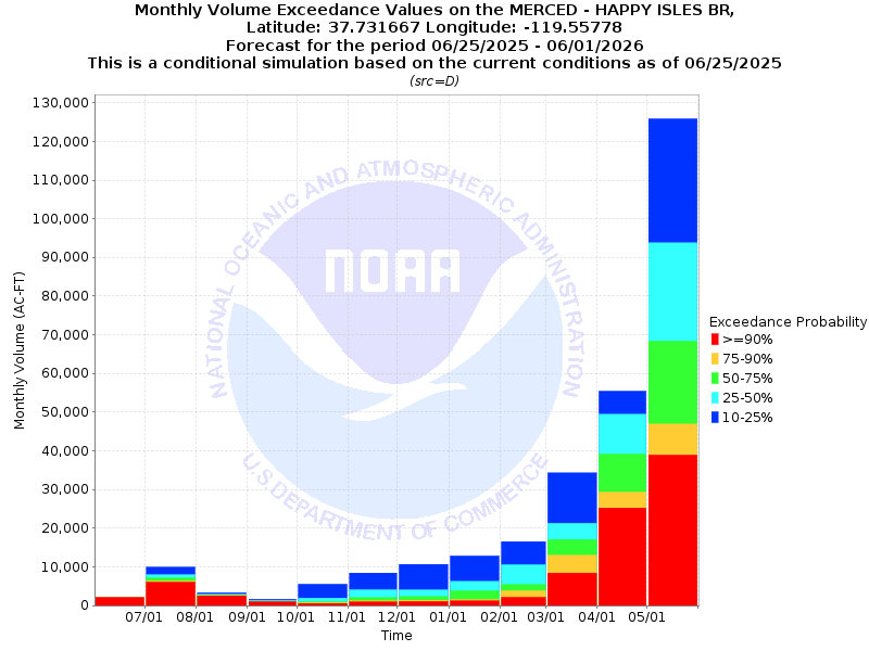
| Monthly Streamflow Volume (1000s of Acre-Feet) Data Updated: Jun 24 2025 at 9:42 AM PDT | ||||||
| Prob | Jun* | Jul | Aug | Sep | Oct | Nov |
| 10% | 33.9 | 12.8 | 4.2 | 1.8 | 5.7 | 8.5 |
| 25% | 33.9 | 10.7 | 3.3 | 1.5 | 2.1 | 4.1 |
| 50% | 33.9 | 9.8 | 3.2 | 1.3 | 1.1 | 2.1 |
| 75% | 33.9 | 8.8 | 3.0 | 1.3 | 0.8 | 1.3 |
| 90% | 33.9 | 8.1 | 2.9 | 1.2 | 0.7 | 1.0 |
| Mean | 69.5 | 31.6 | 7.5 | 2.7 | 2.9 | 3.9 |
| %Mean | 48.8 | 31.0 | 42.7 | 48.1 | 37.9 | 53.8 |
| Prob | Dec | Jan | Feb | Mar | Apr | May |
| 10% | 10.7 | 12.9 | 16.6 | 34.3 | 56.0 | 126.4 |
| 25% | 4.1 | 6.2 | 10.6 | 21.3 | 50.0 | 94.2 |
| 50% | 2.4 | 3.8 | 5.4 | 17.1 | 39.7 | 68.8 |
| 75% | 1.4 | 1.5 | 3.8 | 13.0 | 29.6 | 47.2 |
| 90% | 1.1 | 1.2 | 2.1 | 8.4 | 25.3 | 39.0 |
| Mean | 4.9 | 7.7 | 8.1 | 15.8 | 39.6 | 79.5 |
| %Mean | 49.0 | 49.4 | 66.7 | 108.2 | 100.3 | 86.5 |
| Note 1: %Mean is the "Median forecast monthly value (50%)" divided by the "monthly mean" (displayed as a %) | ||||||
| Note 2: For current month, graphic represents remaining forecast only, text represents observed + remaining forecast. | ||||||
| Location Photographs | ||
| ESRI™ Locator Map |
| Official 7 Day National Weather Service Forecast (CAZ324) |
| Today: Warmer, sunny. Highs 75 to 87. South winds up to 5 mph shifting to the southwest 5 to 15 mph in the afternoon. Tonight: Clear. Lows 55 to 63. Northwest winds up to 10 mph shifting to the east after midnight. Thursday: Sunny. Highs 76 to 88. Southeast winds up to 5 mph shifting to the southwest 5 to 15 mph in the afternoon. Thursday Night: Clear. Lows 56 to 64. West winds up to 5 mph shifting to the east after midnight. Friday: Sunny. Highs 78 to 90. East winds up to 5 mph shifting to the southwest 5 to 15 mph in the afternoon. Friday Night through Sunday: Clear. Lows 58 to 68. Highs 80 to 93. Sunday Night: Mostly clear. Lows 60 to 68. Monday: Sunny. Highs 80 to 92. Monday Night: Mostly clear. Lows 60 to 68. Tuesday: Sunny. Highs 80 to 92. |
| Flood Impacts | |
| 13.27 Feet | Flood of Record: 1/2/97. $178 million in damage to Yosemite Valley. |
| 10.0 Feet | Northside Drive at Wosky Pond, Southside Drive at Chapel Meadow, El Capitan crossover, and Sentinel crossover are impassable to vehicles. |
| 8.2 Feet | Swinging Bridge overtops. Water on road at Northside Drive, Southsie Drive, El Capitan crossover, and Sentinel crossover. |
| 7.5 Feet | Flood Stage. Housekeeping camp and Yosemite Valley backpacker campground begin to flood. |
| 7.0 Feet | North Pines and Lower Pines campgrounds begin flooding. |