
| ||||||||||||||||||
| COSUMNES RIVER - MCCONNELL (MCNC1) | ||||||||||||||||||
| Latitude: 38.36º N | Longitude: 121.34º W | Elevation: 5 Feet | ||||||||||||||||
| Location: Sacramento County in CA | ||||||||||||||||||
| River Group: San Joaquin | ||||||||||||||||||
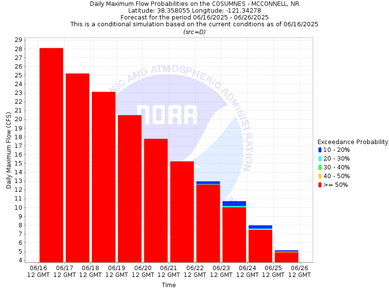
| Issuance Time: | Jun 16 2025 at 6:20 AM PDT |
| Please Note: | Ensemble forecasts produced by CNRFC only consider meteorological uncertainty and do not account for hydrologic uncertainty. |
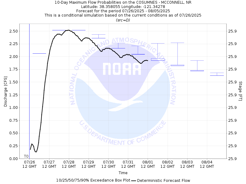
| 10-Day Probability Plot |
| Location Photographs | ||
| ESRI™ Locator Map |
| Official 7 Day National Weather Service Forecast (CAZ017) |
| Today: Sunny. Highs 83 to 93. South winds up to 10 mph with gusts to around 20 mph. Tonight: Clear. Lows 50 to 59. South winds up to 10 mph with gusts to around 20 mph. Tuesday: Sunny. Highs 88 to 96. Light winds becoming west up to 10 mph in the afternoon. Tuesday Night: Clear. Lows 55 to 65. Southwest winds up to 10 mph with gusts to around 20 mph. Wednesday: Sunny. Highs 93 to 101. Southwest winds up to 10 mph. Wednesday Night: Clear. Lows 53 to 63. juneteenth: Sunny. Highs 85 to 95. Thursday Night through Friday Night: Clear. Lows 50 to 58. Highs 84 to 94. Saturday and Saturday Night: Clear. Highs 78 to 84. Lows 51 to 61. Sunday: Sunny. Highs 84 to 90. |
| Flood Impacts | |
| 46.5 Feet | At approximately 44,000 cfs, water exits the river upstream and downstream of Highway 99. Dillard Road is flooded from Highway 99 to Riley Road. Twin Cities Road is flooded from Hardesty Lane to Christensen Road. |
| 44.5 Feet | Flood stage. |
| 41.5 Feet | The Cosumnes River overflow channel begins to flow. |
| 38.5 Feet | Monitor Stage. |