
| ||||||||||||||||||
| MERCED RIVER - YOSEMITE AT POHONO BRIDGE (POHC1) | ||||||||||||||||||
| Latitude: 37.72º N | Longitude: 119.67º W | Elevation: 3862 Feet | ||||||||||||||||
| Location: Mariposa County in CA | ||||||||||||||||||
| River Group: San Joaquin | ||||||||||||||||||
| Issuance Time: | Jul 09 2025 at 7:48 AM PDT |
| Please Note: | Ensemble forecasts produced by CNRFC only consider meteorological uncertainty and do not account for hydrologic uncertainty. |
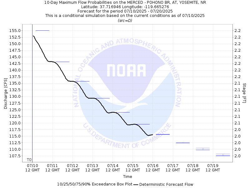
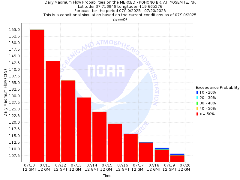
| 10-Day Probability Plot |
| Location Photographs | ||
| ESRI™ Locator Map |
| Official 7 Day National Weather Service Forecast (CAZ324) |
| Today: Sunny. Highs 77 to 89. South winds up to 10 mph shifting to the southwest in the afternoon. Tonight: Clear. Lows 57 to 65. Northeast winds up to 10 mph. Thursday: Warmer, sunny. Highs 80 to 94. Southeast winds up to 10 mph shifting to the southwest in the afternoon. Thursday Night: Clear. Lows 61 to 69. West winds 5 to 10 mph shifting to the northeast after midnight. Friday: Sunny. Highs 83 to 97. East winds up to 5 mph shifting to the west in the afternoon. Friday Night through Monday: Clear. Lows 63 to 72. Highs 84 to 99. Monday Night: Mostly clear. Lows 64 to 72. Tuesday: Sunny. Highs 84 to 98. |
| Flood Impacts | |
| 23.45 Feet | Flood of record...1/3/97. $178 million damage to Yosemite Valley. |
| 13.6 Feet | Lift stations at Housekeeping Camp and Yosemite Creek flooded. Southside Drive at Chapel Meadow impassable. |
| 12.5 Feet | Northside Drive at Wosky Pond, El Capitan crossover, and Sentinel crossover are impassable to vehicles. |
| 12.0 Feet | Water on road at Northside Drive, Southside Drive, El Capitan crossover, Sentinel crossover, and Highway 140 near Cookie Cliff. |
| 11.4 Feet | Water begins to overtop road curbs on Northside Drive. Swinging Bridge overtops. |
| 10.0 Feet | Merced River at Pohono Bridge begins to rise out of its banks. Flood Stage. |
| 9.5 Feet | Lower Pines and Housekeeping Camp begin flooding. |
| 7.0 Feet | RIVER IS CLOSED TO RAFTERS AND FLOATATION DEVICES. |