
| ||||||||||||||||||
| MERCED RIVER - YOSEMITE AT POHONO BRIDGE (POHC1) | ||||||||||||||||||
| Latitude: 37.72º N | Longitude: 119.67º W | Elevation: 3862 Feet | ||||||||||||||||
| Location: Mariposa County in CA | ||||||||||||||||||
| River Group: San Joaquin | ||||||||||||||||||
| Issuance Time: | Jun 26 2025 at 8:06 AM PDT |
| Please Note: | Ensemble forecasts produced by CNRFC only consider meteorological uncertainty and do not account for hydrologic uncertainty. |
| 10-Day Accumulated Volume Plot |
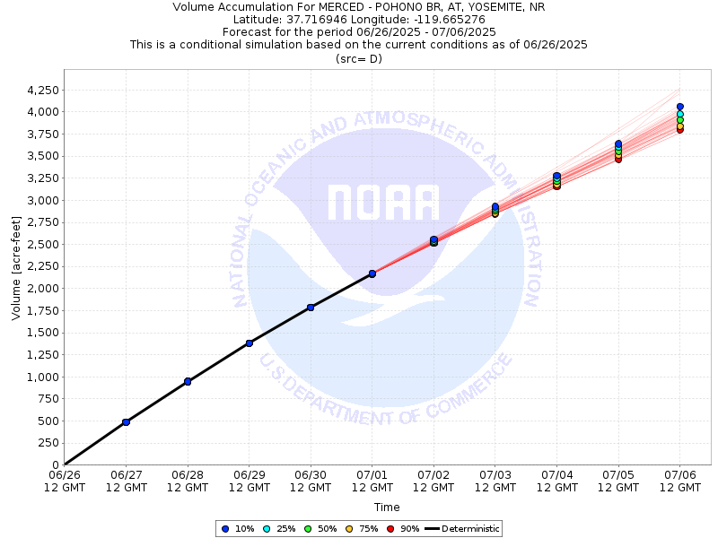
| Tabular 10-Day Streamflow Volume Accumulation (1000s of Acre-Feet) Data Updated: Jun 26 2025 at 8:10 AM PDT | ||||||||||
| Prob | Jun 27 | Jun 28 | Jun 29 | Jun 30 | Jul 01 | |||||
| 10% (Max) | 0.5 | 0.9 | 1.4 | 1.8 | 2.2 | |||||
| 25% | 0.5 | 0.9 | 1.4 | 1.8 | 2.2 | |||||
| 50% (Prob) | 0.5 | 0.9 | 1.4 | 1.8 | 2.2 | |||||
| 75% | 0.5 | 0.9 | 1.4 | 1.8 | 2.2 | |||||
| 90% (Min) | 0.5 | 0.9 | 1.4 | 1.8 | 2.2 | |||||
| RFC FCST | 0.5 | 0.9 | 1.4 | 1.8 | 2.2 | |||||
| Prob | Jul 02 | Jul 03 | Jul 04 | Jul 05 | Jul 06 | |||||
| 10% (Max) | 2.6 | 2.9 | 3.3 | 3.6 | 4.1 | |||||
| 25% | 2.5 | 2.9 | 3.3 | 3.6 | 4.0 | |||||
| 50% (Prob) | 2.5 | 2.9 | 3.2 | 3.6 | 3.9 | |||||
| 75% | 2.5 | 2.9 | 3.2 | 3.5 | 3.8 | |||||
| 90% (Min) | 2.5 | 2.8 | 3.2 | 3.5 | 3.8 | |||||
| Location Photographs | ||
| ESRI™ Locator Map |
| Official 7 Day National Weather Service Forecast (CAZ324) |
| Tonight: Clear. Lows 56 to 64. West winds up to 10 mph shifting to the east after midnight. Friday: Sunny. Highs 78 to 90. South winds up to 5 mph shifting to the southwest 5 to 15 mph in the afternoon. Friday Night: Clear. Lows 58 to 66. West winds up to 10 mph shifting to the northeast after midnight. Saturday: Sunny. Highs 80 to 92. East winds up to 5 mph shifting to the west 5 to 15 mph in the afternoon. Saturday Night: Mostly clear. Lows 59 to 67. West winds 5 to 10 mph shifting to the northeast after midnight. Sunday through Monday: Clear. Highs 79 to 93. Lows 59 to 67. Monday Night through Thursday: Mostly clear. Lows 59 to 69. Highs 79 to 92. |
| Flood Impacts | |
| 23.45 Feet | Flood of record...1/3/97. $178 million damage to Yosemite Valley. |
| 13.6 Feet | Lift stations at Housekeeping Camp and Yosemite Creek flooded. Southside Drive at Chapel Meadow impassable. |
| 12.5 Feet | Northside Drive at Wosky Pond, El Capitan crossover, and Sentinel crossover are impassable to vehicles. |
| 12.0 Feet | Water on road at Northside Drive, Southside Drive, El Capitan crossover, Sentinel crossover, and Highway 140 near Cookie Cliff. |
| 11.4 Feet | Water begins to overtop road curbs on Northside Drive. Swinging Bridge overtops. |
| 10.0 Feet | Merced River at Pohono Bridge begins to rise out of its banks. Flood Stage. |
| 9.5 Feet | Lower Pines and Housekeeping Camp begin flooding. |
| 7.0 Feet | RIVER IS CLOSED TO RAFTERS AND FLOATATION DEVICES. |