
| ||||||||||||||||||
| SACRAMENTO RIVER - RED BLUFF (RDBC1) | ||||||||||||||||||
| Latitude: 40.15º N | Longitude: 122.20º W | Elevation: 231 Feet | ||||||||||||||||
| Location: Tehama County in CA | ||||||||||||||||||
| River Group: Upper Sacramento | ||||||||||||||||||
| Issuance Time: | Jun 28 2025 at 8:39 AM PDT |
| Please Note: | Ensemble forecasts produced by CNRFC only consider meteorological uncertainty and do not account for hydrologic uncertainty. |
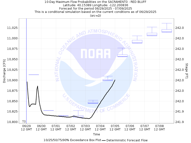
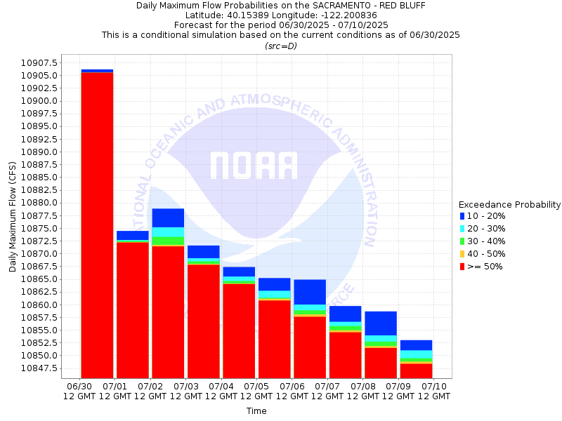
| 10-Day Probability Plot |
| Location Photographs | ||
| ESRI™ Locator Map |
| Official 7 Day National Weather Service Forecast (CAZ015) |
| Today: Sunny. Highs 100 to 106. Light winds becoming south up to 10 mph in the afternoon. Tonight: Clear. Lows 68 to 74. South winds up to 10 mph. Monday: Sunny. Highs around 100. Light winds becoming south around 10 mph in the afternoon. Monday Night: Mostly clear. Lows 69 to 75. Southeast winds up to 10 mph. Gusts up to 20 mph in the evening. Tuesday: Mostly sunny. A slight chance of rain showers in the afternoon. Highs around 99. Light winds. Tuesday Night: Mostly clear. Lows 69 to 75. Wednesday: Mostly sunny. Highs 96 to 102. Wednesday Night: Mostly clear. Lows around 69. Thursday through Saturday: Clear. Highs 89 to 99. Lows 61 to 69. |
| Flood Impacts | |
| 259.6 Feet | Extensive flooding problems begin to happen in low lying areas of Red Bluff. |
| 257.6 Feet | Water starts into the houses on Mary Lane, Howell Street and surrounding streets. |
| 256.9 Feet | Trailer Park just south of Antelope Avenue (SR-36) bridge on left bank of river starts to take on water. Water is up to the parking lot at city park on right bank of river. High water in Paynes Creek Slough closes Belle Mill Road at Kaer Avenue. |
| 256.6 Feet | Overflow of east bank of river downstream of gage begins. Housing development in the area is threatened. |
| 248.6 Feet | The river starts to flow eastward into sand slough on the left bank upstream of the gage. |