
| ||||||||||||||||||
| SALMON RIVER - SOMES BAR (SBRC1) | ||||||||||||||||||
| Latitude: 41.38º N | Longitude: 123.48º W | Elevation: 483 Feet | ||||||||||||||||
| Location: Siskiyou County in CA | ||||||||||||||||||
| River Group: North Coast | ||||||||||||||||||
| Issuance Time: | Jun 16 2025 at 6:37 AM PDT |
| Please Note: | Ensemble forecasts produced by CNRFC only consider meteorological uncertainty and do not account for hydrologic uncertainty. Flow data on this product are unregulated / full natural flow. |
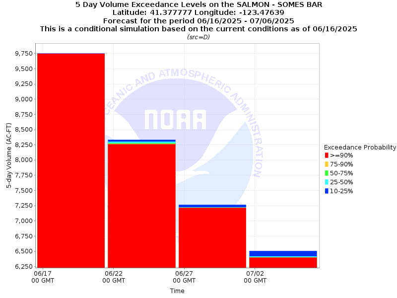
| 4x5-Day Probability Plot |
| Tabular 4 x 5-Day Streamflow Volume Data | |||||
| Observed Peak 1-Day Streamflow Volume: (April 1 at 12 UTC to Current Date at 12 UTC) | Observed 04/08/2025 18.3kaf | ||||
| Forecast Peak 1-Day Streamflow Volume: (Current Date at 12 UTC to August 1 at 12 UTC) | 10% (Max) 06/17/2025 2.1kaf | 25% 06/17/2025 2.1kaf | 50% (Prob) 06/17/2025 2.1kaf | 75% 06/17/2025 2.1kaf | 90% (Min) 06/17/2025 2.1kaf |
| Tabular 5-Day Volume Accumulations (1000s of Acre-Feet) | ||||
| Probability | 06/16 to 06/21 | 06/21 to 06/26 | 06/26 to 07/01 | 07/01 to 07/06 |
| 10% | 9.8 kaf | 8.3 kaf | 7.3 kaf | 6.5 kaf |
| 25% | 9.7 kaf | 8.3 kaf | 7.2 kaf | 6.4 kaf |
| 50% (Median) | 9.7 kaf | 8.3 kaf | 7.2 kaf | 6.4 kaf |
| 75% | 9.7 kaf | 8.3 kaf | 7.2 kaf | 6.4 kaf |
| 90% | 9.7 kaf | 8.3 kaf | 7.2 kaf | 6.4 kaf |
| Location Photographs | ||
| ESRI™ Locator Map |
| Official 7 Day National Weather Service Forecast (CAZ080) |
| Tonight: Mostly cloudy. Chance of rain and snow showers This Evening, then slight chance of rain showers after midnight. Snow level 5500 feet This Evening. Lows in the mid 30s to mid 40s. West winds 10 to 15 mph decreasing to around 5 mph after midnight. Chance of precipitation 30 percent. Saturday: Mostly cloudy with a 30 percent chance of showers. Snow level 6000 feet in the afternoon. Highs in the lower 50s to lower 60s. Northwest winds 10 to 15 mph. Saturday Night: Partly cloudy. A 10 percent chance of showers in the evening. Lows in the lower to mid 40s. Northwest winds 10 to 15 mph shifting to the north around 5 mph after midnight. Sunday: Sunny. Highs in the mid 60s to mid 70s. Northeast winds 5 to 10 mph. Sunday Night: Clear. Lows in the mid 40s to lower 50s. Northeast winds 5 to 10 mph. Monday: Sunny, warmer. Highs in the mid 70s to mid 80s. Monday Night: Mostly clear. Lows in the lower to mid 50s. Tuesday and Tuesday Night: Clear. Highs in the lower 80s to lower 90s. Lows in the lower to mid 50s. Wednesday: Sunny. Highs in the mid 70s to mid 80s. Wednesday Night through Thursday Night: Mostly clear. Lows in the lower to mid 50s. Highs in the mid 70s to mid 80s. Friday: Sunny. Highs in the mid 70s to mid 80s. |