
| ||||||||||||||||||
| SYCAN RIVER - BEATTY (SCNO3) | ||||||||||||||||||
| Latitude: 42.49º N | Longitude: 121.28º W | Elevation: 4325 Feet | ||||||||||||||||
| Location: Klamath County in OR | ||||||||||||||||||
| River Group: North Coast | ||||||||||||||||||
| Issuance Time: | Jun 16 2025 at 6:37 AM PDT |
| Please Note: | Ensemble forecasts produced by CNRFC only consider meteorological uncertainty and do not account for hydrologic uncertainty. |
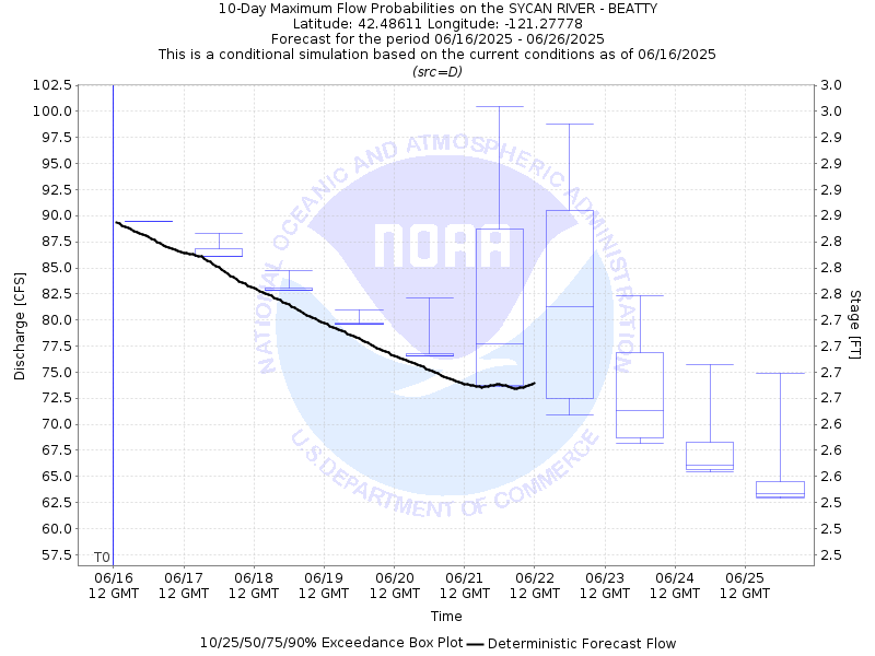
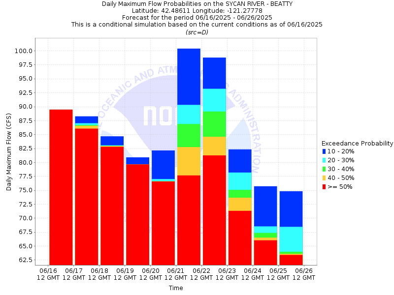
| 10-Day Probability Plot |
| Location Photographs | ||
| ESRI™ Locator Map |
| Official 7 Day National Weather Service Forecast (ORZ030) |
| Today: Partly cloudy early This Morning, then mostly cloudy with a slight chance of showers late This Morning. Partly cloudy with a slight chance of thunderstorms This Afternoon. Highs in the lower to mid 70s. West winds 5 to 10 mph. Tonight: Mostly clear. Lows in the mid 30s to mid 40s. Northwest winds 10 to 15 mph decreasing to around 5 mph after midnight. Tuesday: Sunny. Highs in the mid 70s to lower 80s. Southwest winds 5 to 10 mph. Tuesday Night: Clear. Lows in the lower to mid 40s. Northwest winds 10 to 15 mph decreasing to around 5 mph well after midnight. Wednesday: Sunny. Highs in the mid 70s to lower 80s. Light winds becoming west 5 to 10 mph in the late morning and afternoon. Wednesday Night and juneteenth: Mostly clear. Lows in the lower to mid 40s. Highs in the mid 70s to lower 80s. Thursday Night: Mostly clear. Areas of frost after midnight. Lows in the mid 30s to mid 40s. Friday: Sunny. Highs in the lower 60s to lower 70s. Friday Night and Saturday: Mostly cloudy with a chance of rain and snow showers. Cooler. Lows in the lower to mid 30s. Highs in the mid 50s to mid 60s. Saturday Night: Partly cloudy with a slight chance of rain showers. Areas of frost after midnight. Lows in the lower to mid 30s. Sunday: Partly cloudy. Warmer. Areas of frost in the morning. Highs in the lower to mid 60s. |