
| ||||||||||||||||||
| SYCAN RIVER - BEATTY (SCNO3) | ||||||||||||||||||
| Latitude: 42.49º N | Longitude: 121.28º W | Elevation: 4325 Feet | ||||||||||||||||
| Location: Klamath County in OR | ||||||||||||||||||
| River Group: North Coast | ||||||||||||||||||
| Issuance Time: | Apr 30 2025 at 9:03 AM PDT |
| Please Note: | Ensemble forecasts produced by CNRFC only consider meteorological uncertainty and do not account for hydrologic uncertainty. Flow data on this product are unregulated / full natural flow. |
| Monthly Probability Plot |
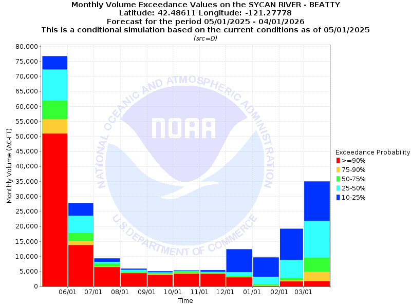
| Monthly Streamflow Volume (1000s of Acre-Feet) Data Updated: Apr 30 2025 at 9:07 AM PDT | ||||||
| Prob | Apr* | May | Jun | Jul | Aug | Sep |
| 10% | 77.8 | 81.1 | 31.7 | 10.0 | 6.1 | 5.1 |
| 25% | 77.8 | 77.2 | 24.4 | 8.7 | 5.6 | 4.9 |
| 50% | 77.8 | 67.3 | 18.9 | 7.8 | 5.1 | 4.4 |
| 75% | 77.8 | 60.1 | 16.0 | 6.9 | 4.7 | 4.2 |
| 90% | 77.8 | 52.8 | 14.2 | 6.5 | 4.4 | 3.9 |
| Mean | 23.4 | 20.2 | 6.7 | 1.8 | 1.0 | 1.1 |
| %Mean | 332.5 | 333.2 | 282.1 | 433.3 | 510.0 | 400.0 |
| Prob | Oct | Nov | Dec | Jan | Feb | Mar |
| 10% | 5.6 | 5.6 | 12.4 | 9.7 | 19.2 | 35.0 |
| 25% | 5.3 | 5.0 | 4.9 | 3.3 | 8.8 | 21.8 |
| 50% | 5.0 | 4.6 | 3.6 | 0.7 | 2.9 | 9.6 |
| 75% | 4.6 | 4.3 | 3.2 | 0.3 | 2.0 | 4.9 |
| 90% | 4.3 | 4.2 | 3.0 | 0.2 | 1.6 | 1.8 |
| Mean | 1.3 | 1.9 | 3.8 | 5.8 | 9.3 | 18.8 |
| %Mean | 384.6 | 242.1 | 94.7 | 12.1 | 31.2 | 51.1 |
| Note 1: %Mean is the "Median forecast monthly value (50%)" divided by the "monthly mean" (displayed as a %) | ||||||
| Note 2: For current month, graphic represents remaining forecast only, text represents observed + remaining forecast. | ||||||
| Location Photographs | ||
| ESRI™ Locator Map |
| Official 7 Day National Weather Service Forecast (ORZ030) |
| Tonight: Clear. Lows in the mid 30s. Northeast winds 5 to 10 mph. Thursday: Sunny. Highs in the mid 60s to mid 70s. East winds around 5 mph shifting to the southeast in the afternoon. Thursday Night: Clear. Lows in the lower to mid 40s. Southeast winds around 5 mph. Friday: Sunny in the morning, then partly cloudy with a 20 percent chance of thunderstorms in the afternoon. Highs in the lower to mid 70s. South winds 10 to 15 mph. Friday Night: Mostly cloudy. Chance of showers and slight chance of thunderstorms in the evening, then rain likely after midnight. Lows in the mid 30s to lower 40s. West winds 10 to 15 mph. Chance of precipitation 70 percent. Saturday: Rain in the morning, then chance of rain in the afternoon. Much cooler. Highs in the mid 40s to lower 50s. Saturday Night: Mostly cloudy. Slight chance of rain and snow in the evening. Colder. Lows in the mid 20s to lower 30s. Sunday and Sunday Night: Mostly clear. Highs in the lower to mid 50s. Lows in the mid 20s to mid 30s. Monday and Monday Night: Mostly clear. Highs in the lower to mid 60s. Lows in the lower 30s to lower 40s. Tuesday and Tuesday Night: Mostly clear. Highs in the mid 60s to mid 70s. Lows in the mid 30s to mid 40s. Wednesday: Sunny. Slight chance of rain in the afternoon. Highs in the mid 60s to lower 70s. |