
| ||||||||||||||||||
| DEER CREEK - SCOTTS FLAT RESERVOIR (SOVC1) | ||||||||||||||||||
| Latitude: 39.27º N | Longitude: 120.93º W | Elevation: 3075 Feet | ||||||||||||||||
| Location: Nevada County in CA | ||||||||||||||||||
| River Group: Lower Sacramento | ||||||||||||||||||
| Issuance Time: | Jun 16 2025 at 6:22 AM PDT |
| Please Note: | Ensemble forecasts produced by CNRFC only consider meteorological uncertainty and do not account for hydrologic uncertainty. Flow data on this product are unregulated / full natural flow. |
| Monthly Probability Plot |
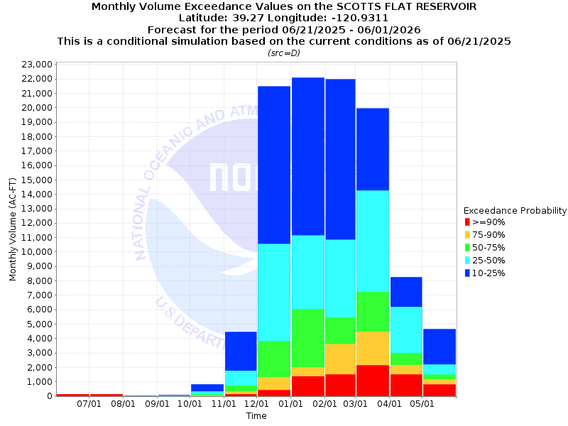
| Monthly Streamflow Volume (1000s of Acre-Feet) Data Updated: Jun 16 2025 at 6:28 AM PDT | ||||||
| Prob | Jun* | Jul | Aug | Sep | Oct | Nov |
| 10% | 0.6 | 0.2 | 0.0 | 0.1 | 0.8 | 4.4 |
| 25% | 0.6 | 0.1 | 0.0 | 0.0 | 0.3 | 1.8 |
| 50% | 0.6 | 0.1 | 0.0 | 0.0 | 0.1 | 0.7 |
| 75% | 0.6 | 0.1 | 0.0 | 0.0 | 0.0 | 0.3 |
| 90% | 0.6 | 0.1 | 0.0 | 0.0 | 0.0 | 0.1 |
| Mean | + | + | + | + | + | + |
| %Mean | + | + | + | + | + | + |
| Prob | Dec | Jan | Feb | Mar | Apr | May |
| 10% | 21.5 | 22.1 | 22.0 | 19.9 | 8.3 | 4.6 |
| 25% | 10.5 | 11.1 | 10.8 | 14.3 | 6.2 | 2.2 |
| 50% | 3.8 | 6.0 | 5.4 | 7.2 | 3.0 | 1.5 |
| 75% | 1.3 | 2.0 | 3.6 | 4.5 | 2.1 | 1.2 |
| 90% | 0.4 | 1.4 | 1.5 | 2.1 | 1.5 | 0.8 |
| Mean | + | + | + | + | + | + |
| %Mean | + | + | + | + | + | + |
| Note 1: %Mean is the "Median forecast monthly value (50%)" divided by the "monthly mean" (displayed as a %) | ||||||
| Note 2: For current month, graphic represents remaining forecast only, text represents observed + remaining forecast. | ||||||
| Location Photographs | ||
| ESRI™ Locator Map |
| Official 7 Day National Weather Service Forecast (CAZ069) |
| Tonight: Clear, colder. Lows 38 to 53 higher elevations and 46 to 58 lower elevations. Prevailing south winds up to 15 mph with gusts to around 30 mph. Friday: Sunny. Highs 52 to 67 higher elevations and 62 to 74 lower elevations. Prevailing southwest winds up to 15 mph with gusts to around 40 mph and except southwest up to 30 mph with gusts to around 45 mph over ridges. Friday Night: Clear, colder. Lows 28 to 43 higher elevations and 38 to 50 lower elevations. Prevailing southwest winds up to 15 mph with gusts to around 40 mph. Over ridges, prevailing southwest winds 20 to 30 mph with gusts to around 45 mph decreasing to 10 to 20 mph after midnight. Saturday: Sunny. Highs 48 to 63 higher elevations and 61 to 71 lower elevations. Prevailing west winds up to 15 mph with gusts to around 30 mph. Saturday Night: Clear. Lows 30 to 45 higher elevations and 41 to 54 lower elevations. Prevailing west winds 5 to 15 mph with gusts to around 30 mph shifting to the northeast after midnight. Sunday: Sunny, warmer. Highs 59 to 74. Sunday Night: Clear. Lows 39 to 54. Monday: Sunny, warmer. Highs 64 to 79. Monday Night: Partly cloudy. Lows 44 to 59. Tuesday: Mostly sunny. Warmer. Highs 67 to 82. Tuesday Night through Thursday: Clear. Lows 47 to 62. Highs 70 to 85. |