
| ||||||||||||||||||
| CUYAMA RIVER - TWITCHELL RESERVOIR (TWDC1) | ||||||||||||||||||
| Latitude: 34.98º N | Longitude: 120.32º W | Elevation: 740 Feet | ||||||||||||||||
| Location: Santa Barbara County in CA | ||||||||||||||||||
| River Group: Southern California | ||||||||||||||||||
| Issuance Time: | Jul 07 2025 at 7:58 AM PDT |
| Please Note: | Ensemble forecasts produced by CNRFC only consider meteorological uncertainty and do not account for hydrologic uncertainty. |
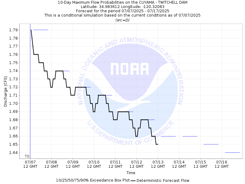
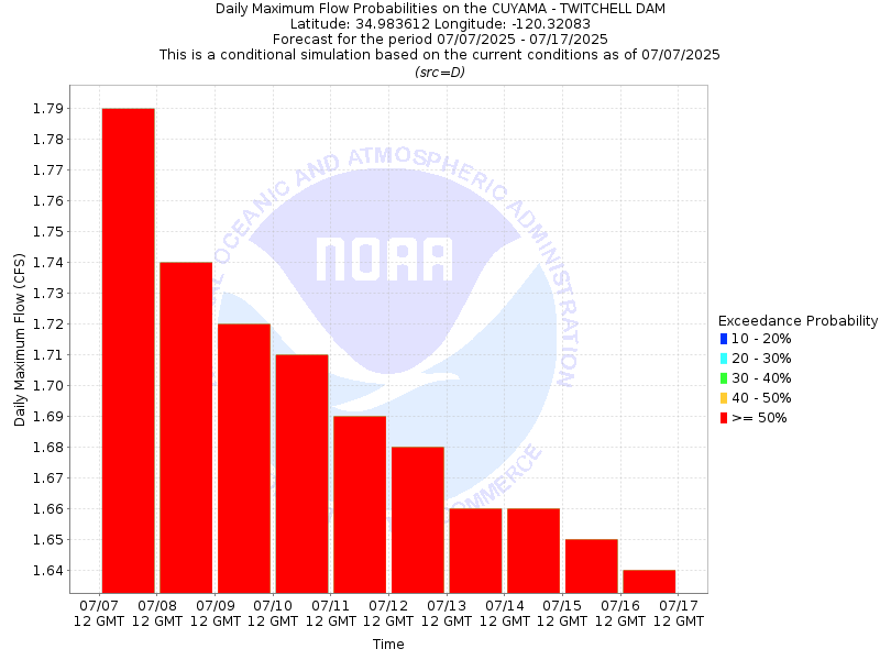
| 10-Day Probability Plot |
| Location Photographs | ||
| ESRI™ Locator Map |
| Official 7 Day National Weather Service Forecast (CAZ341) |
| Tonight: Partly cloudy early then low clouds and fog. Lows in the lower to mid 50s. Tuesday: Low clouds and fog in the morning then sunny. Highs in the mid 60s to lower 70s. Tuesday Night: Mostly clear early then low clouds and fog. Fog locally dense with visibility one quarter mile or less. Lows around 50. Wednesday: Low clouds and fog in the morning then sunny. Fog locally dense with visibility one quarter mile or less. Highs in the mid 60s to mid 70s except the mid 70s to around 80 farthest inland. West winds around 15 mph in the afternoon. Wednesday Night: Mostly clear early then low clouds and fog. Fog locally dense with visibility one quarter mile or less. Lows in the upper 40s to mid 50s. West winds around 15 mph in the evening. Thursday: Low clouds and fog in the morning then sunny. Highs in the upper 60s to mid 70s except the lower to mid 80s farthest inland. Thursday Night: Partly cloudy early then low clouds and fog. Lows in the upper 40s to mid 50s. Friday: Low clouds and fog in the morning then sunny. Highs in the mid 60s to mid 70s. Friday Night: Mostly clear early then low clouds and fog. Lows in the upper 40s to mid 50s. Saturday: Low clouds and fog in the morning then sunny. Highs in the mid 60s to mid 70s. Saturday Night: Mostly clear early then low clouds and fog. Lows in the upper 40s to mid 50s. Sunday: Low clouds and fog in the morning then sunny. Highs in the mid 60s to mid 70s. Sunday Night: Mostly clear early then low clouds and fog. Lows in the mid 50s. Monday: Low clouds and fog in the morning then sunny. Highs in the mid 60s to mid 70s. |