
| ||||||||||||||||||
| SILVER CREEK - UNION VALLEY RESERVOIR (UNVC1) | ||||||||||||||||||
| Latitude: 38.86º N | Longitude: 120.44º W | Elevation: 4870 Feet | ||||||||||||||||
| Location: El Dorado County in CA | ||||||||||||||||||
| River Group: Lower Sacramento | ||||||||||||||||||
| Issuance Time: | Jul 06 2025 at 7:54 AM PDT |
| Please Note: | Ensemble forecasts produced by CNRFC only consider meteorological uncertainty and do not account for hydrologic uncertainty. |
| 10-Day Accumulated Volume Plot |
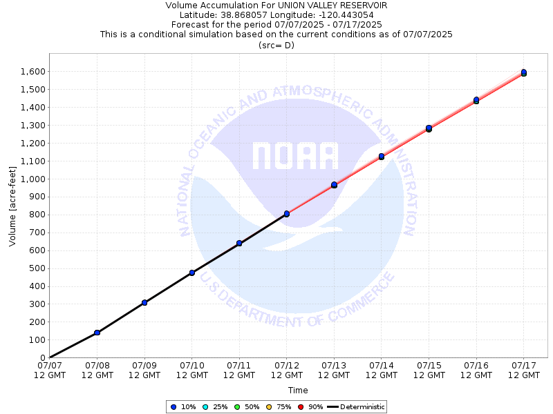
| Tabular 10-Day Streamflow Volume Accumulation (1000s of Acre-Feet) Data Updated: Jul 06 2025 at 8:02 AM PDT | ||||||||||
| Prob | Jul 07 | Jul 08 | Jul 09 | Jul 10 | Jul 11 | |||||
| 10% (Max) | 0.2 | 0.5 | 0.8 | 1.1 | 1.4 | |||||
| 25% | 0.2 | 0.5 | 0.8 | 1.1 | 1.4 | |||||
| 50% (Prob) | 0.2 | 0.5 | 0.8 | 1.1 | 1.4 | |||||
| 75% | 0.2 | 0.5 | 0.8 | 1.1 | 1.4 | |||||
| 90% (Min) | 0.2 | 0.5 | 0.8 | 1.1 | 1.4 | |||||
| RFC FCST | 0.2 | 0.5 | 0.8 | 1.1 | 1.4 | |||||
| Prob | Jul 12 | Jul 13 | Jul 14 | Jul 15 | Jul 16 | |||||
| 10% (Max) | 1.7 | 2.0 | 2.3 | 2.6 | 2.9 | |||||
| 25% | 1.7 | 2.0 | 2.3 | 2.6 | 2.9 | |||||
| 50% (Prob) | 1.7 | 2.0 | 2.3 | 2.6 | 2.9 | |||||
| 75% | 1.7 | 2.0 | 2.3 | 2.6 | 2.9 | |||||
| 90% (Min) | 1.7 | 2.0 | 2.3 | 2.6 | 2.9 | |||||
| Location Photographs | ||
| ESRI™ Locator Map |
| Official 7 Day National Weather Service Forecast (CAZ069) |
| Today: Sunny, warmer. Highs 69 to 84 higher elevations and 79 to 89 lower elevations. Light winds becoming southwest up to 10 mph in the afternoon. Tonight: Clear. Lows 46 to 61 higher elevations and 55 to 69 lower elevations. Prevailing west winds up to 10 mph in the evening becoming light. Monday: Sunny. Highs 69 to 84 higher elevations and 80 to 90 lower elevations. Light winds becoming southwest up to 10 mph in the afternoon. Monday Night: Clear. Lows 45 to 60 higher elevations and 55 to 67 lower elevations. Prevailing southwest winds up to 10 mph in the evening becoming light. Tuesday: Sunny. Highs 66 to 81 higher elevations and 77 to 87 lower elevations. Light winds becoming southwest up to 10 mph in the afternoon. Tuesday Night: Clear. Lows 47 to 62. Wednesday: Sunny. Highs 70 to 85. Wednesday Night through Saturday: Clear. Lows 51 to 66. Highs 74 to 89. |