
| ||||||||||||||||||
| WILLIAMSON RIVER - KLAMATH AGENCY (WKAO3) | ||||||||||||||||||
| Latitude: 42.74º N | Longitude: 121.83º W | Elevation: 4483 Feet | ||||||||||||||||
| Location: Klamath County in OR | ||||||||||||||||||
| River Group: North Coast | ||||||||||||||||||
| Issuance Time: | Jun 16 2025 at 6:37 AM PDT |
| Please Note: | Ensemble forecasts produced by CNRFC only consider meteorological uncertainty and do not account for hydrologic uncertainty. Flow data on this product are unregulated / full natural flow. |
| Monthly Probability Plot |
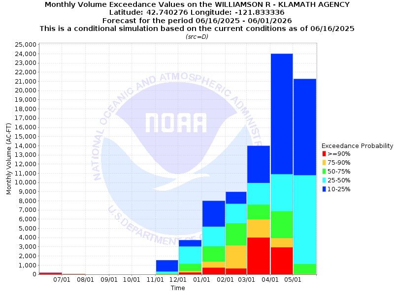
| Monthly Streamflow Volume (1000s of Acre-Feet) Data Updated: Jun 16 2025 at 6:44 AM PDT | ||||||
| Prob | Jun* | Jul | Aug | Sep | Oct | Nov |
| 10% | 0.2 | 0.0 | 0.0 | 0.0 | 0.0 | 1.5 |
| 25% | 0.2 | 0.0 | 0.0 | 0.0 | 0.0 | 0.3 |
| 50% | 0.1 | 0.0 | 0.0 | 0.0 | 0.0 | 0.1 |
| 75% | 0.1 | 0.0 | 0.0 | 0.0 | 0.0 | 0.0 |
| 90% | 0.1 | 0.0 | 0.0 | 0.0 | 0.0 | 0.0 |
| Mean | 3.6 | 1.2 | 0.4 | 0.3 | 0.9 | 2.6 |
| %Mean | 2.8 | 0.0 | 0.0 | 0.0 | 0.0 | 3.8 |
| Prob | Dec | Jan | Feb | Mar | Apr | May |
| 10% | 3.7 | 8.0 | 9.0 | 14.0 | 24.0 | 21.3 |
| 25% | 3.0 | 5.2 | 7.7 | 9.9 | 10.9 | 10.8 |
| 50% | 1.1 | 3.0 | 5.6 | 7.6 | 6.9 | 1.1 |
| 75% | 0.4 | 1.4 | 3.1 | 6.0 | 3.9 | 0.0 |
| 90% | 0.2 | 0.7 | 0.6 | 4.0 | 2.9 | 0.0 |
| Mean | 5.0 | 5.9 | 7.5 | 15.3 | 15.2 | 8.3 |
| %Mean | 22.0 | 50.8 | 74.7 | 49.7 | 45.4 | 13.3 |
| Note 1: %Mean is the "Median forecast monthly value (50%)" divided by the "monthly mean" (displayed as a %) | ||||||
| Note 2: For current month, graphic represents remaining forecast only, text represents observed + remaining forecast. | ||||||
| Location Photographs | ||
| ESRI™ Locator Map |
| Official 7 Day National Weather Service Forecast (ORZ029) |
| Today: Partly cloudy until early afternoon then clearing. Highs in the lower to mid 70s. West winds around 5 mph increasing to 10 to 15 mph This Afternoon. Tonight: Mostly clear. Lows in the lower to mid 40s. Northwest winds 10 to 15 mph decreasing to around 5 mph well after midnight. Tuesday: Sunny. Highs in the mid 70s to lower 80s. Northwest winds around 5 mph shifting to the southwest in the late morning and early afternoon, then shifting to the west late in the afternoon. Tuesday Night: Clear. Lows in the lower 40s to lower 50s. Northwest winds 10 to 15 mph decreasing to around 5 mph well after midnight. Wednesday: Sunny. Highs in the mid 70s to mid 80s. Northwest winds around 5 mph shifting to the west in the afternoon. Wednesday Night and juneteenth: Clear. Lows in the lower 40s to lower 50s. Highs in the mid 70s to mid 80s. Thursday Night and Friday: Mostly clear. Not as warm. Lows in the mid 30s to mid 40s. Highs in the mid 60s to mid 70s. Friday Night: Partly cloudy with a slight chance of rain showers in the evening, then mostly cloudy with a chance of rain and snow showers after midnight. Colder. Lows in the lower 30s to lower 40s. Saturday: Mostly cloudy. Chance of rain and snow showers in the morning, then chance of rain showers in the afternoon. Highs in the lower 50s to lower 60s. Saturday Night: Partly cloudy. Slight chance of rain showers in the evening. Areas of frost after midnight. Lows in the lower 30s to lower 40s. Sunday: Partly cloudy in the morning then becoming sunny. Warmer. Areas of frost in the morning. Highs in the mid 60s to lower 70s. |