
| ||||||||||||||||||
| WILLIAMSON RIVER - CHILOQUIN (WMSO3) | ||||||||||||||||||
| Latitude: 42.57º N | Longitude: 121.88º W | Elevation: 4149 Feet | ||||||||||||||||
| Location: Klamath County in OR | ||||||||||||||||||
| River Group: North Coast | ||||||||||||||||||
| Issuance Time: | Jun 16 2025 at 6:37 AM PDT |
| Please Note: | Ensemble forecasts produced by CNRFC only consider meteorological uncertainty and do not account for hydrologic uncertainty. |
| 10-Day Accumulated Volume Plot |
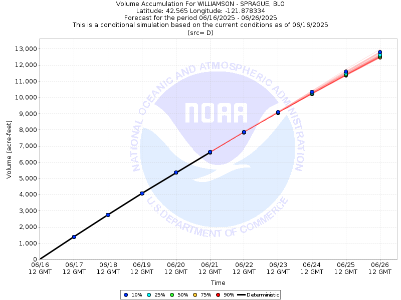
| Tabular 10-Day Streamflow Volume Accumulation (1000s of Acre-Feet) Data Updated: Jun 16 2025 at 6:44 AM PDT | ||||||||||
| Prob | Jun 17 | Jun 18 | Jun 19 | Jun 20 | Jun 21 | |||||
| 10% (Max) | 1.4 | 2.8 | 4.1 | 5.4 | 6.6 | |||||
| 25% | 1.4 | 2.8 | 4.1 | 5.4 | 6.6 | |||||
| 50% (Prob) | 1.4 | 2.8 | 4.1 | 5.4 | 6.6 | |||||
| 75% | 1.4 | 2.8 | 4.1 | 5.4 | 6.6 | |||||
| 90% (Min) | 1.4 | 2.8 | 4.1 | 5.4 | 6.6 | |||||
| RFC FCST | 1.4 | 2.8 | 4.1 | 5.4 | 6.6 | |||||
| Prob | Jun 22 | Jun 23 | Jun 24 | Jun 25 | Jun 26 | |||||
| 10% (Max) | 7.9 | 9.1 | 10.3 | 11.6 | 12.8 | |||||
| 25% | 7.9 | 9.1 | 10.3 | 11.5 | 12.6 | |||||
| 50% (Prob) | 7.8 | 9.1 | 10.2 | 11.4 | 12.6 | |||||
| 75% | 7.8 | 9.1 | 10.2 | 11.4 | 12.5 | |||||
| 90% (Min) | 7.8 | 9.0 | 10.2 | 11.4 | 12.5 | |||||
| Location Photographs | ||
| ESRI™ Locator Map |
| Official 7 Day National Weather Service Forecast (ORZ029) |
| Today: Partly cloudy until early afternoon then clearing. Highs in the lower to mid 70s. West winds around 5 mph increasing to 10 to 15 mph This Afternoon. Tonight: Mostly clear. Lows in the lower to mid 40s. Northwest winds 10 to 15 mph decreasing to around 5 mph well after midnight. Tuesday: Sunny. Highs in the mid 70s to lower 80s. Northwest winds around 5 mph shifting to the southwest in the late morning and early afternoon, then shifting to the west late in the afternoon. Tuesday Night: Clear. Lows in the lower 40s to lower 50s. Northwest winds 10 to 15 mph decreasing to around 5 mph well after midnight. Wednesday: Sunny. Highs in the mid 70s to mid 80s. Northwest winds around 5 mph shifting to the west in the afternoon. Wednesday Night and juneteenth: Clear. Lows in the lower 40s to lower 50s. Highs in the mid 70s to mid 80s. Thursday Night and Friday: Mostly clear. Not as warm. Lows in the mid 30s to mid 40s. Highs in the mid 60s to mid 70s. Friday Night: Partly cloudy with a slight chance of rain showers in the evening, then mostly cloudy with a chance of rain and snow showers after midnight. Colder. Lows in the lower 30s to lower 40s. Saturday: Mostly cloudy. Chance of rain and snow showers in the morning, then chance of rain showers in the afternoon. Highs in the lower 50s to lower 60s. Saturday Night: Partly cloudy. Slight chance of rain showers in the evening. Areas of frost after midnight. Lows in the lower 30s to lower 40s. Sunday: Partly cloudy in the morning then becoming sunny. Warmer. Areas of frost in the morning. Highs in the mid 60s to lower 70s. |
| Flood Impacts | |
| 10.0 Feet | Widespread flooding is occurring along the Williamson River from the Highway 97 bridge downstream to Upper Klamath Lake. Widespread farm land flooding is occurring. Numerous structures are flooded. |
| 9.0 Feet | The Williamson River is at flood stage. Water exceeds the channel of the river and begins to impact structures along the river and in low-lying areas near the river. |
| 8.0 Feet | The Williamson River is near bankfull stage. Water is nearing many structures along and enar the river. Water is close to structures at the Water Wheel Campground near Highway 97. |