
| ||||||||||||||||||
| WILLIAMSON RIVER - CHILOQUIN (WMSO3) | ||||||||||||||||||
| Latitude: 42.57º N | Longitude: 121.88º W | Elevation: 4149 Feet | ||||||||||||||||
| Location: Klamath County in OR | ||||||||||||||||||
| River Group: North Coast | ||||||||||||||||||
| Issuance Time: | Jun 16 2025 at 6:37 AM PDT |
| Please Note: | Ensemble forecasts produced by CNRFC only consider meteorological uncertainty and do not account for hydrologic uncertainty. Flow data on this product are unregulated / full natural flow. |
| Monthly Probability Plot |
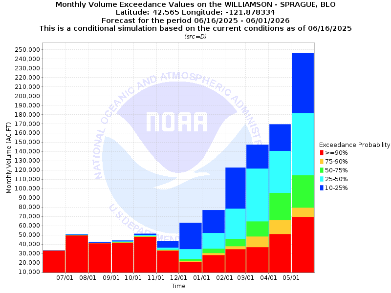
| Monthly Streamflow Volume (1000s of Acre-Feet) Data Updated: Jun 16 2025 at 6:44 AM PDT | ||||||
| Prob | Jun* | Jul | Aug | Sep | Oct | Nov |
| 10% | 57.3 | 50.9 | 42.4 | 43.9 | 51.2 | 43.5 |
| 25% | 57.2 | 50.1 | 41.6 | 42.8 | 50.0 | 36.2 |
| 50% | 56.9 | 49.8 | 41.1 | 42.2 | 48.9 | 33.9 |
| 75% | 56.8 | 49.5 | 41.0 | 41.7 | 48.3 | 33.4 |
| 90% | 56.8 | 49.4 | 40.8 | 41.5 | 47.9 | 32.8 |
| Mean | 51.1 | 32.9 | 29.0 | 30.4 | 36.4 | 40.4 |
| %Mean | 111.4 | 151.4 | 141.7 | 138.8 | 134.3 | 83.9 |
| Prob | Dec | Jan | Feb | Mar | Apr | May |
| 10% | 63.2 | 76.9 | 122.7 | 147.3 | 169.3 | 246.3 |
| 25% | 34.6 | 52.1 | 78.2 | 121.5 | 140.6 | 181.4 |
| 50% | 24.1 | 35.0 | 45.8 | 64.4 | 95.4 | 114.3 |
| 75% | 21.7 | 30.3 | 37.6 | 48.1 | 65.8 | 79.3 |
| 90% | 20.7 | 28.0 | 34.4 | 36.7 | 50.8 | 69.3 |
| Mean | 49.9 | 59.2 | 65.4 | 97.0 | 101.0 | 89.1 |
| %Mean | 48.3 | 59.1 | 70.0 | 66.4 | 94.5 | 128.3 |
| Note 1: %Mean is the "Median forecast monthly value (50%)" divided by the "monthly mean" (displayed as a %) | ||||||
| Note 2: For current month, graphic represents remaining forecast only, text represents observed + remaining forecast. | ||||||
| Location Photographs | ||
| ESRI™ Locator Map |
| Official 7 Day National Weather Service Forecast (ORZ029) |
| Today: Partly cloudy until early afternoon then clearing. Highs in the lower to mid 70s. West winds around 5 mph increasing to 10 to 15 mph This Afternoon. Tonight: Mostly clear. Lows in the lower to mid 40s. Northwest winds 10 to 15 mph decreasing to around 5 mph well after midnight. Tuesday: Sunny. Highs in the mid 70s to lower 80s. Northwest winds around 5 mph shifting to the southwest in the late morning and early afternoon, then shifting to the west late in the afternoon. Tuesday Night: Clear. Lows in the lower 40s to lower 50s. Northwest winds 10 to 15 mph decreasing to around 5 mph well after midnight. Wednesday: Sunny. Highs in the mid 70s to mid 80s. Northwest winds around 5 mph shifting to the west in the afternoon. Wednesday Night and juneteenth: Clear. Lows in the lower 40s to lower 50s. Highs in the mid 70s to mid 80s. Thursday Night and Friday: Mostly clear. Not as warm. Lows in the mid 30s to mid 40s. Highs in the mid 60s to mid 70s. Friday Night: Partly cloudy with a slight chance of rain showers in the evening, then mostly cloudy with a chance of rain and snow showers after midnight. Colder. Lows in the lower 30s to lower 40s. Saturday: Mostly cloudy. Chance of rain and snow showers in the morning, then chance of rain showers in the afternoon. Highs in the lower 50s to lower 60s. Saturday Night: Partly cloudy. Slight chance of rain showers in the evening. Areas of frost after midnight. Lows in the lower 30s to lower 40s. Sunday: Partly cloudy in the morning then becoming sunny. Warmer. Areas of frost in the morning. Highs in the mid 60s to lower 70s. |
| Flood Impacts | |
| 10.0 Feet | Widespread flooding is occurring along the Williamson River from the Highway 97 bridge downstream to Upper Klamath Lake. Widespread farm land flooding is occurring. Numerous structures are flooded. |
| 9.0 Feet | The Williamson River is at flood stage. Water exceeds the channel of the river and begins to impact structures along the river and in low-lying areas near the river. |
| 8.0 Feet | The Williamson River is near bankfull stage. Water is nearing many structures along and enar the river. Water is close to structures at the Water Wheel Campground near Highway 97. |