
| ||||||||||||||||||
| SANTA MARGARITA - YSIDORA (YDRC1) | ||||||||||||||||||
| Latitude: 33.31º N | Longitude: 117.35º W | Elevation: 75 Feet | ||||||||||||||||
| Location: San Diego County in CA | ||||||||||||||||||
| River Group: Southern California | ||||||||||||||||||
| Issuance Time: | Jul 08 2025 at 10:04 AM PDT |
| Please Note: | Ensemble forecasts produced by CNRFC only consider meteorological uncertainty and do not account for hydrologic uncertainty. Flow data on this product are unregulated / full natural flow. |
| Monthly Probability Plot |
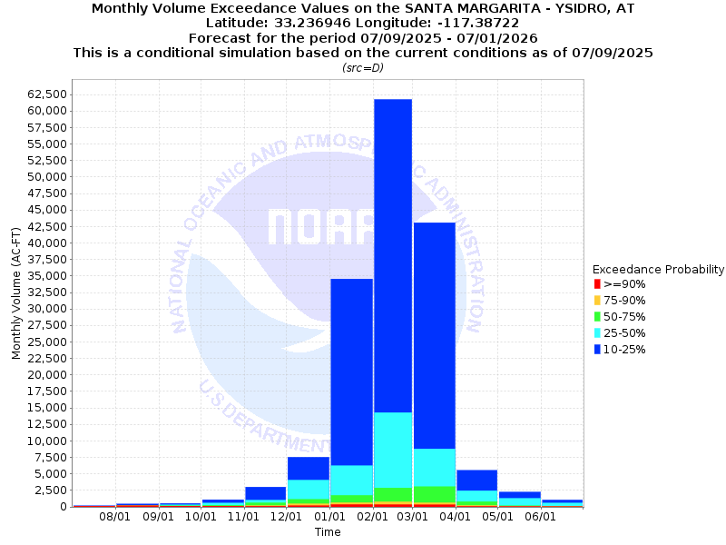
| Monthly Streamflow Volume (1000s of Acre-Feet) Data Updated: Jul 08 2025 at 10:13 AM PDT | ||||||
| Prob | Jul* | Aug | Sep | Oct | Nov | Dec |
| 10% | 0.2 | 0.4 | 0.5 | 1.1 | 3.0 | 7.5 |
| 25% | 0.1 | 0.2 | 0.3 | 0.6 | 1.0 | 4.1 |
| 50% | 0.1 | 0.2 | 0.2 | 0.3 | 0.6 | 1.1 |
| 75% | 0.1 | 0.2 | 0.1 | 0.1 | 0.2 | 0.5 |
| 90% | 0.1 | 0.2 | 0.1 | 0.1 | 0.1 | 0.2 |
| Mean | 0.2 | 0.3 | 0.2 | 0.5 | 0.8 | 3.6 |
| %Mean | 50.0 | 66.7 | 100.0 | 60.0 | 75.0 | 30.6 |
| Prob | Jan | Feb | Mar | Apr | May | Jun |
| 10% | 34.6 | 61.8 | 43.1 | 5.5 | 2.2 | 1.1 |
| 25% | 6.2 | 14.3 | 8.8 | 2.5 | 1.3 | 0.6 |
| 50% | 1.8 | 2.9 | 3.0 | 0.8 | 0.2 | 0.1 |
| 75% | 0.6 | 0.8 | 0.6 | 0.2 | 0.1 | 0.1 |
| 90% | 0.4 | 0.3 | 0.3 | 0.1 | 0.1 | 0.0 |
| Mean | 11.7 | 12.6 | 9.2 | 3.1 | 1.3 | 0.5 |
| %Mean | 15.4 | 23.0 | 32.6 | 25.8 | 15.4 | 20.0 |
| Note 1: %Mean is the "Median forecast monthly value (50%)" divided by the "monthly mean" (displayed as a %) | ||||||
| Note 2: For current month, graphic represents remaining forecast only, text represents observed + remaining forecast. | ||||||
| Location Photographs | ||
| ESRI™ Locator Map |
| Official 7 Day National Weather Service Forecast (CAZ043) |
| Tonight: Mostly clear This Evening and becoming partly cloudy. Patchy fog overnight. Lows 60 to 66. Areas of winds northwest 10 mph This Evening becoming light. Wednesday: Partly cloudy with patchy fog in the morning and Becoming mostly sunny. Highs 75 to 78 near the coast to 82 to 85 inland. Areas of winds west to 10 mph. Wednesday Night: Mostly clear in the evening and becoming partly cloudy overnight with patchy fog. Lows 60 to 66. Areas of winds west 10 mph in the evening becoming light. Thursday: Partly cloudy with patchy fog in the morning and Becoming mostly sunny. Highs 74 to 78 near the coast to 82 to 85 inland. Light winds becoming west 10 mph in the afternoon. Thursday Night: Mostly clear in the evening and becoming partly cloudy overnight with patchy fog. Lows 59 to 64. Light winds. Friday: Cloudy in the morning and becoming partly cloudy. Patchy fog in the morning. Highs 72 to 75 near the coast to 80 inland. Friday Night: Mostly clear in the evening and becoming cloudy overnight with patchy fog. Lows 57 to 63. Saturday: Cloudy with patchy fog in the morning and becoming mostly sunny. Highs 70 to 74 near the coast to 78 inland. Saturday Night: Mostly clear in the evening and becoming cloudy overnight with patchy fog. Lows 58 to 63. Sunday: Cloudy in the morning and becoming mostly sunny. Highs 71 to 75 near the coast to 80 inland. Sunday Night: Mostly clear in the evening and becoming mostly cloudy. Lows 57 to 64. Monday: Cloudy in the morning and becoming partly cloudy. Highs 71 to 75 near the coast to 76 to 79 inland. Monday Night: Mostly clear in the evening and becoming mostly cloudy. Lows 58 to 63. Tuesday: Cloudy in the morning and becoming mostly sunny. Highs 70 to 74 near the coast to 77 inland. |
| Flood Impacts | |
| 16.0 Feet | Major flood, 37,000 cfs. Widespread inundation of Camp Pendleton with evacuations likely. Flood of Record Jan 16, 1993. |
| 13.33 Feet | Moderate flood stage, 17,000 cfs. Vandegrift Road is flooded for several miles downstream of the gage site. Stuart Mesa Road is flooded near the bridge. |
| 11.16 Feet | Minor flood stage, 8,000 cfs. Vandegrift Road has begun to flood downstream of the gage. Stuart Mesa Road closures can be expected. |
| 8.18 Feet | 2,500 cfs. The river has reached monitor stage. Personnel begin regular patrols along the levee. |