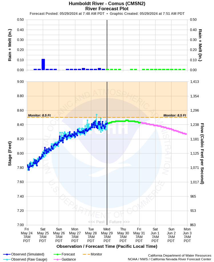
| HUMBOLDT RIVER - COMUS (CMSN2) | ||
| Latitude: 40.99º N | Longitude: 117.32º W | Elevation: 4360 Feet |
| Location: Humboldt County in NV | ||
| River Group: Humboldt | ||
| Forecast Issued: | May 05 2024 at 8:44 AM PDT | Next Issuance: | May 06 2024 at 9:00 AM PDT |
| Monitor Stage: 8.5 Feet | Flood Stage: 9.5 Feet |
Prev. Point | Next Point | Tabular |
Back to Points | Back to Home | Ensemble Fcst |
 |
Historical Stage/Flow Data |
|||
|
Water Year
|
Peak Discharge (cfs)
|
Stage (feet)
|
Date
|
| Most Recent 5 Years | |||
2022* |
164 |
3.25 |
Jun 20, 2022 |
2021* |
279 |
3.96 |
Jun 10, 2021 |
2020* |
364 |
4.61 |
Jun 6, 2020 |
2019* |
3,230 |
11.17 |
Jun 15, 2019 |
2018* |
586 |
5.36 |
Apr 15, 2018 |
| Historical High Stage/Flow Events (Period of Record - April 1895** to Present) - Ranked by Flow | |||
1984* |
9,900 |
12.25 |
Apr 24, 1984 |
1952* |
5,860 |
11.52 |
May 6, 1952 |
1983* |
5,210 |
11.76 |
Jun 14, 1983 |
2017* |
4,960 |
11.29 |
Mar 31, 2017 |
2005* |
4,710 |
11.44 |
May 28, 2005 |
1969* |
3,910 |
10.64 |
Apr 18, 1969 |
| * Discharge affected to unknown degree by regulation or diversion | |||
| ** Missing records from 1927 to 1945 | |||
| Location Photographs | ||
| ESRI™ Locator Map |
| Impacts - E19 Information | |
| 8.5 Feet | Some very minor flooding at scattered locations in reach. No flooding in Winnemucca. |
| 9.0 Feet | Very minor lowland flooding in reach. No flooding in Winnemucca. |
| 9.5 Feet | Flood Stage - Minor lowland flooding throughout reach. No flooding in Winnemucca. |
| 10.0 Feet | Minor to moderate lowland flooding throughout reach. Some rural roads near river begin to flood. Very minor flooding begins in Winnemucca with sewer backups, and lowest parts of town begin to flood (similar to 02/1986 flood). |
| 10.5 Feet | Moderate lowland flooding through reach with some rural roads flooded. Minor flooding in lower parts of Winnemucca with sewer backups. Main area impacted is between Union Pacific railroad and 2nd Street beneath Interstate 80 (similar to 02/1986, 06/1995, and 05/1998 floods). |
| 11.0 Feet | Moderate to major lowland flooding throughout reach. Many rural roads near river flooded. Minor to moderate flooding in lower portions of Winnemucca. Main area impacted is between Union Pacific railroad and Golconda Street on west and 2nd Street beneath Interstate 80 on the east (similar to 06/1921 and 04/1969 floods). |
| 11.5 Feet | Major flooding throughout reach, except moderate flooding in lower portion of Winnemucca. Many rural roads near river flooded. Main area impacted is between Union Pacific railroad and Golconda Street on the west and 2nd Street on the east not including Interstate 80 (similar to 06/1983 flood). |
| 12.0 Feet | Major flooding, including Winnemucca. All secondary roads, stretches of rail and some ranch buildings near river flood. River 2 to 4 miles wide through Humboldt County. Lower parts of Winnemucca flood between Union Paific railroad and Golconda Street on the west and 2nd Street on the east not including Interstate 80. A dozen homes and several businesses affected. Large loss of livestock in area (greater than 05/1952 flood, but not as severe as record 04/1984 flood). |
| 12.5 Feet | Near record to record flooding in Humboldt County. Most secondary roads near the river, bridges over some primary roads, long stretches of rail, and many ranch buildings flood. River 2 to 5 miles wide through Humboldt County. Winnemucca flooded between Union Pacific railroad and 2nd Street on the east. US Highway 95 bridge in Winnemucca may be affected. Many homes and businesses flood in Winnemucca. Large losses of livestock in area (similar to record 04/1984 flood). |