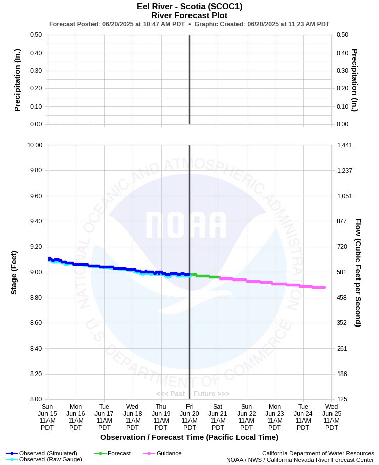
| EEL RIVER - SCOTIA (SCOC1) | ||
| Latitude: 40.49º N | Longitude: 124.1º W | Elevation: 36 Feet |
| Location: Humboldt County in CA | ||
| River Group: North Coast | ||
| Forecast Issued: | Jun 16 2025 at 6:07 AM PDT | Next Issuance: | Jun 17 2025 at 9:00 AM PDT |
| Action/ Monitor: 45.0 Ft | Minor Flood: 51.0 Ft | Moderate Flood: 60.0 Ft | Major Flood: 65.0 Ft |
Prev. Point | Next Point | Tabular |
Back to Points | Back to Home | Ensemble Fcst |
 |
Historical Stage/Flow Data |
|||
|
Water Year
|
Peak Discharge (cfs)
|
Stage (feet)
|
Date
|
| Most Recent 5 Years | |||
2024 |
105,000 |
33.12 |
Jan 14, 2024 |
2023 |
165,000 |
40.89 |
Mar 15, 2023 |
2022 |
68,900 |
27.64 |
Oct 25, 2021 |
2021 |
30,100 |
19.80 |
Feb 2, 2021 |
2020 |
50,200 | 24.17 |
Jan 26, 2020 |
| Historical High Stage/Flow Events (Period of Record - Oct 1916 to Present)* - Ranked by Flow | |||
1965 |
752,000 |
72.00 |
Dec 23, 1964 |
1956 |
541,000 |
61.90 |
Dec 22, 1955
|
1974 |
387,000 |
52.31 |
Jan 16, 1974 |
| 1995 | 368,000 | 51.30 | Jan 9, 1995 |
| 1986 | 364,000 | 51.08 | Feb 17, 1986 |
| 1997 | 360,000 | 54.97 | Jan 1, 1997 |
| Location Photographs | ||
| ESRI™ Locator Map |
| Flood Impacts | |
| 74.0 Feet | Extensive and severe flooding throughout the river valley with major damage to roads, bridges and structures. There will be numerous road closures including the Avenue of the Giants (Highway 254) and US Highway 101. |
| 72.0 Feet | Extensive and severe flooding of all areas adjacent to the river is expected with possible damage to roads, bridges and other structures. Expect many road closures including the Avenue of the Giants (Highway 254) and possibly US Highway 101. |
| 67.0 Feet | Expect significant flooding in all areas near the river with numerous road closures, including the Avenue of the Giants (Highway 254). |
| 62.0 Feet | Flooding of many low lying areas near the river is likely. Numerous closures along the Avenue of the Giants (Highway 254). |
| 55.0 Feet | Flooding of low lying areas near Shively is likely, along with possible closure of portions of the Avenue of the Giants (Highway 254). |
| 52.0 Feet | Minor flooding in the Shively area is possible. |
| 50.0 Feet | Flooding of the River's Edge RV Park in Rio Dell is likely. Occupants of the park will need to move their vehicles to higher ground. |
| 48.0 Feet | Flooding of the River's Edge RV Park in Rio Dell is expected. Occupants of the park may need to move their vehicles to higher ground. |
| 46.0 Feet | Minor flooding is possible in the northern portion of the River's Edge RV Park in Rio Dell. Occupants of the park need to be ready to move their vehicles to higher ground. |