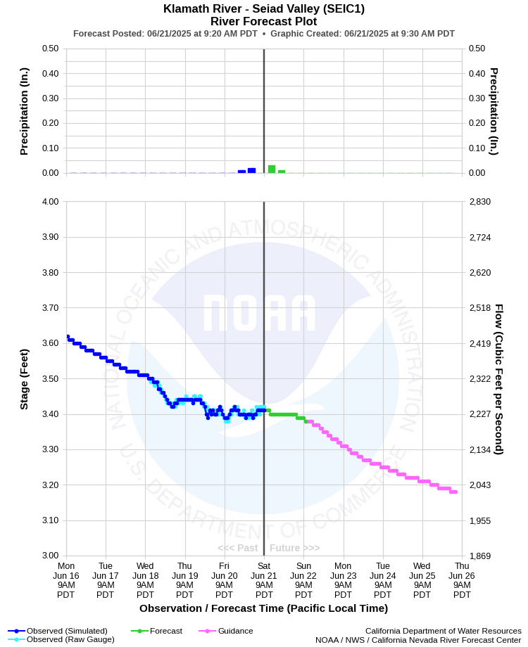
| KLAMATH RIVER - SEIAD VALLEY (SEIC1) | ||
| Latitude: 41.85º N | Longitude: 123.23º W | Elevation: 1320 Feet |
| Location: Siskiyou County in CA | ||
| River Group: North Coast | ||
| Forecast Issued: | Jun 21 2025 at 9:30 AM PDT | Next Issuance: | Jun 22 2025 at 9:00 AM PDT |
| Action/ Monitor: 13.0 Ft | Minor Flood: 15.0 Ft | Moderate Flood: 20.0 Ft | Major Flood: 28.0 Ft |
Prev. Point | Next Point | Tabular |
Back to Points | Back to Home | Ensemble Fcst |
 |
Historical Stage/Flow Data |
|||
|
Water Year
|
Peak Discharge (cfs)
|
Stage (feet)
|
Date
|
| Most Recent 5 Years | |||
2024* |
10,400*** |
8.61 |
Jan 28, 2024 |
2023* |
9,370 |
8.15 |
Apr 30, 2023 |
2022* |
5,130 |
5.79 |
Apr 16, 2022 |
2021* |
4,860 |
5.61 |
Jan 13, 2021 |
2020* |
7,270 | 7.08 |
Apr 24, 2020 |
| Historical High Stage/Flow Events (Period of Record - Jul 1951 to Present)** - Ranked by Flow | |||
1965* |
165,000 |
33.75 |
Dec 23, 1964 |
1974* |
126,000 |
29.65 |
Jan 16, 1974
|
1956* |
122,000 |
29.20 |
Dec 22, 1955 |
| 1997* | 117,000 | 28.72 | Jan 1, 1997 |
| 2006* | 74,000 | 23.17 | Dec 31, 2005 |
| Location Photographs | ||
| ESRI™ Locator Map |
| Flood Impacts | |
| 33.75 Feet | Major flooding is occurring along the entire reach of the Klamath River in Siskiyou County. Much of Highway 96 is impassable. |
| 28.0 Feet | Expect considerable flooding along the Klamath River in Siskiyou County. Sections of Highway 96 are flooded. |
| 20.0 Feet | Highway 96 innundated in low-lying spots along the Klamath River in Siskiyou County. Flooding is also likely at the confluence with the Scott River and the confluence with Indian Creek. |
| 15.0 Feet | The Klamath River is at flood stage. The Klamath River begins to flow out of its banks in some areas. Some low-lying structures may be flooded. |
| 13.0 Feet | The Klamath River is nearing bankfull. |