
| ||||||||||||||||||
| VAN DUZEN RIVER - BRIDGEVILLE (BRGC1) | ||||||||||||||||||
| Latitude: 40.48º N | Longitude: 123.89º W | Elevation: 358 Feet | ||||||||||||||||
| Location: Humboldt County in CA | ||||||||||||||||||
| River Group: North Coast | ||||||||||||||||||
| Issuance Time: | Jun 16 2025 at 6:32 AM PDT |
| Please Note: | Ensemble forecasts produced by CNRFC only consider meteorological uncertainty and do not account for hydrologic uncertainty. Flow data on this product are unregulated / full natural flow. |
| Monthly Probability Plot |
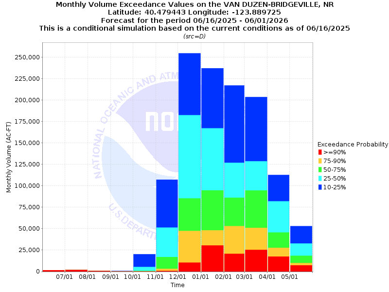
| Monthly Streamflow Volume (1000s of Acre-Feet) Data Updated: Jun 16 2025 at 6:38 AM PDT | ||||||
| Prob | Jun* | Jul | Aug | Sep | Oct | Nov |
| 10% | 5.4 | 1.9 | 0.7 | 0.7 | 20.3 | 107.2 |
| 25% | 5.4 | 1.8 | 0.7 | 0.4 | 5.3 | 51.2 |
| 50% | 5.4 | 1.8 | 0.6 | 0.2 | 0.7 | 17.0 |
| 75% | 5.4 | 1.8 | 0.6 | 0.1 | 0.3 | 3.3 |
| 90% | 5.4 | 1.8 | 0.6 | 0.1 | 0.1 | 0.6 |
| Mean | 8.6 | 2.1 | 0.9 | 0.9 | 6.1 | 38.8 |
| %Mean | 62.8 | 85.7 | 66.7 | 22.2 | 11.5 | 43.8 |
| Prob | Dec | Jan | Feb | Mar | Apr | May |
| 10% | 254.4 | 237.0 | 216.9 | 203.5 | 112.6 | 52.9 |
| 25% | 182.2 | 166.9 | 126.8 | 128.6 | 81.8 | 32.7 |
| 50% | 85.2 | 94.7 | 86.2 | 94.5 | 45.5 | 18.4 |
| 75% | 47.3 | 48.1 | 52.9 | 51.0 | 27.8 | 9.9 |
| 90% | 10.3 | 30.5 | 20.6 | 25.3 | 17.6 | 7.3 |
| Mean | 107.7 | 116.4 | 100.8 | 102.7 | 55.9 | 26.2 |
| %Mean | 79.1 | 81.4 | 85.5 | 92.0 | 81.4 | 70.2 |
| Note 1: %Mean is the "Median forecast monthly value (50%)" divided by the "monthly mean" (displayed as a %) | ||||||
| Note 2: For current month, graphic represents remaining forecast only, text represents observed + remaining forecast. | ||||||
| Location Photographs | ||
| ESRI™ Locator Map |
| Official 7 Day National Weather Service Forecast (CAZ106) |
| Tonight: Partly cloudy in the evening then becoming mostly cloudy. Lows 39 to 49. Northwest wind around 20 mph in the evening. Friday: Mostly cloudy in the morning then becoming partly cloudy. Slight chance of rain in the afternoon. Snow level 4500 to 5000 feet. Highs 57 to 72. Friday Night: Mostly cloudy. Chance of rain in the evening. Snow level 5000 feet. Lows 38 to 48. Saturday: Mostly sunny. Highs 60 to 75. Saturday Night and Sunday: Partly cloudy. Lows 40 to 50. Highs 65 to 80. Sunday Night: Mostly clear. Lows 42 to 52. Monday through Tuesday Night: Partly cloudy. Highs 75 to 90. Lows 45 to 55. Wednesday: Sunny. Highs 75 to 90. Wednesday Night and Thursday: Partly cloudy. Lows 47 to 57. Highs 75 to 90. |
| Flood Impacts | |
| 25.0 Feet | Extensive, severe, record flooding from Bridgeville downstream to the mouth including portions of US Highway 101. All persons near the river should be prepared to take appropriate actions to protect life and property. |
| 24.0 Feet | Extensive, severe, near record flooding from Bridgeville downstream to the mouth including portions of US Highway 101. All persons near the river should be prepared to take appropriate actions to protect life and property. |
| 23.0 Feet | Extensive, severe flooding with closure of Highway 36 east of Carlotta to near the Grizzly Creek Bridge. River Bar Road in the Starvation Flats area will be impassable. |
| 21.0 Feet | Flooding of Highway 36 east of Carlotta and near the Grizzly Creek Bridge with water over the road in numerous locations. Portions of River Bar Road in Starvation Flats will likely be impassable. Water level in Grizzly Creek State Park will approach Highway 36. |
| 20.0 Feet | Flooding of Highway 36, especially east of Carlotta and near Grizzly Creek State Park. Portions of River Bar Road in the Starvation Flats area are likely to be impassable. In the State Park water may reach near the office. |
| 19.0 Feet | Flooding of Highway 36 near Grizzly Creek State Park and along River Bar Road in the Starvation flats area. Water level at the State Park reaches the parking lot. |
| 18.0 Feet | Minor flooding of Highway 36 near Grizzly Creek State Park and in lower portions of the State Park itself. Moderate flooding of River Bar Road in the Starvation Flats area. |
| 17.0 Feet | Flooding begins in lower portions of Grizzly Creek State Park and along River Bar Road. |