
| ||||||||||||||||||
| EEL RIVER - SCOTIA (SCOC1) | ||||||||||||||||||
| Latitude: 40.49º N | Longitude: 124.1º W | Elevation: 36 Feet | ||||||||||||||||
| Location: Humboldt County in CA | ||||||||||||||||||
| River Group: North Coast | ||||||||||||||||||
| Issuance Time: | Jul 06 2025 at 8:14 AM PDT |
| Please Note: | Ensemble forecasts produced by CNRFC only consider meteorological uncertainty and do not account for hydrologic uncertainty. Flow data on this product are unregulated / full natural flow. |
| Monthly Probability Plot |
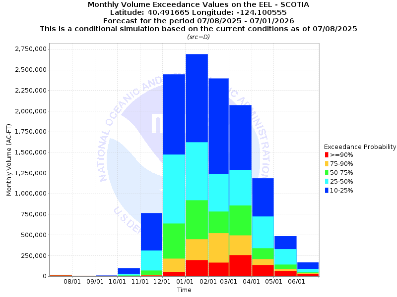
| Monthly Streamflow Volume (1000s of Acre-Feet) Data Updated: Jul 06 2025 at 8:17 AM PDT | ||||||
| Prob | Jul* | Aug | Sep | Oct | Nov | Dec |
| 10% | 18.4 | 5.8 | 7.5 | 96.0 | 763.6 | 2443.6 |
| 25% | 18.3 | 5.4 | 3.6 | 26.7 | 312.0 | 1472.7 |
| 50% | 15.7 | 5.3 | 2.3 | 7.8 | 67.4 | 636.0 |
| 75% | 12.5 | 1.9 | 1.2 | 3.4 | 18.2 | 211.4 |
| 90% | 12.5 | 1.9 | 1.0 | 1.9 | 7.4 | 52.9 |
| Mean | 21.1 | 8.8 | 7.5 | 36.7 | 259.2 | 925.9 |
| %Mean | 74.4 | 60.2 | 30.7 | 21.3 | 26.0 | 68.7 |
| Prob | Jan | Feb | Mar | Apr | May | Jun |
| 10% | 2688.4 | 2392.8 | 2070.6 | 1186.0 | 485.8 | 167.4 |
| 25% | 1621.2 | 1236.3 | 1288.7 | 722.5 | 329.0 | 88.8 |
| 50% | 917.6 | 781.9 | 856.0 | 337.8 | 139.4 | 45.8 |
| 75% | 447.3 | 521.0 | 492.5 | 206.3 | 88.2 | 35.7 |
| 90% | 194.0 | 162.3 | 254.7 | 134.8 | 60.4 | 28.1 |
| Mean | 1135.1 | 1011.1 | 999.8 | 516.3 | 228.4 | 79.7 |
| %Mean | 80.8 | 77.3 | 85.6 | 65.4 | 61.0 | 57.5 |
| Note 1: %Mean is the "Median forecast monthly value (50%)" divided by the "monthly mean" (displayed as a %) | ||||||
| Note 2: For current month, graphic represents remaining forecast only, text represents observed + remaining forecast. | ||||||
| Location Photographs | ||
| ESRI™ Locator Map |
| Official 7 Day National Weather Service Forecast (CAZ103) |
| Tonight: Mostly clear in the evening then becoming mostly cloudy. Lows 49 to 59. West wind around 10 mph shifting to the east overnight. Monday: Mostly cloudy in the morning then clearing. Highs 64 to 79. West wind around 10 mph. Monday Night: Partly cloudy in the evening then becoming mostly cloudy. Patchy fog overnight. Lows 46 to 56. Southwest wind around 10 mph. Tuesday: Mostly cloudy. Patchy fog. Highs 60 to 73. West wind around 10 mph. Tuesday Night and Wednesday: Mostly cloudy. Patchy fog. Lows 46 to 56. Highs 60 to 73. Northwest wind up to 10 mph. Wednesday Night and Thursday: Mostly cloudy. Lows 49 to 59. Highs 62 to 76. Thursday Night through Saturday: Partly cloudy. Lows 49 to 59. Highs 65 to 80. Saturday Night and Sunday: Mostly cloudy. Lows 49 to 59. Highs 63 to 77. |
| Flood Impacts | |
| 74.0 Feet | Extensive and severe flooding throughout the river valley with major damage to roads, bridges and structures. There will be numerous road closures including the Avenue of the Giants (Highway 254) and US Highway 101. |
| 72.0 Feet | Extensive and severe flooding of all areas adjacent to the river is expected with possible damage to roads, bridges and other structures. Expect many road closures including the Avenue of the Giants (Highway 254) and possibly US Highway 101. |
| 67.0 Feet | Expect significant flooding in all areas near the river with numerous road closures, including the Avenue of the Giants (Highway 254). |
| 62.0 Feet | Flooding of many low lying areas near the river is likely. Numerous closures along the Avenue of the Giants (Highway 254). |
| 55.0 Feet | Flooding of low lying areas near Shively is likely, along with possible closure of portions of the Avenue of the Giants (Highway 254). |
| 52.0 Feet | Minor flooding in the Shively area is possible. |
| 50.0 Feet | Flooding of the River's Edge RV Park in Rio Dell is likely. Occupants of the park will need to move their vehicles to higher ground. |
| 48.0 Feet | Flooding of the River's Edge RV Park in Rio Dell is expected. Occupants of the park may need to move their vehicles to higher ground. |
| 46.0 Feet | Minor flooding is possible in the northern portion of the River's Edge RV Park in Rio Dell. Occupants of the park need to be ready to move their vehicles to higher ground. |