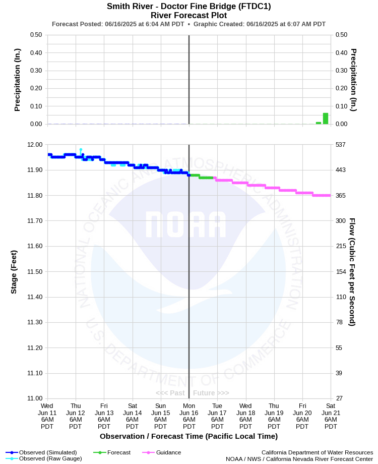
| SMITH RIVER - DOCTOR FINE BRIDGE (FTDC1) | ||
| Latitude: 41.88º N | Longitude: 124.14º W | Elevation: 0 Feet |
| Location: Del Norte County in CA | ||
| River Group: North Coast | ||
| Forecast Issued: | Jun 16 2025 at 6:07 AM PDT | Next Issuance: | Jun 17 2025 at 9:00 AM PDT |
| Action/ Monitor: 27.0 Ft | Minor Flood: 33.0 Ft | Moderate Flood: 36.0 Ft | Major Flood: 39.0 Ft |
Prev. Point | Next Point | Tabular |
Back to Points | Back to Home | Ensemble Fcst |
 |
Historical Stage/Flow Data |
|||
|
Water Year
|
Peak Discharge (cfs)
|
Stage (feet)
|
Date
|
| Most Recent 5 Years | |||
2024 |
161,000* |
35.04 |
Jan 13, 2024 |
2023 |
81,800* |
29.72 |
Mar 13, 2023 |
2022 |
40,100* |
24.67 |
Jan 4, 2022 |
2021 |
91,700* |
30.59 |
Jan 13, 2021 |
2020 |
49,500* |
26.14 |
Jan 26, 2020 |
| Historical High Stage/Flow Events (Period of Record - Oct 1950 to Present) - Ranked by Flow | |||
1965 |
207,000* |
39.50 |
Dec 22, 1964 |
1956 |
176,500* |
37.40 |
Dec 22, 1955 |
1972 |
173,700* |
37.20 |
Mar 03, 1972 |
1951 |
170,000* |
36.90 |
Oct 29, 1950 |
| * Estimated flow (Not Official) | |||
| Location Photographs | ||
| ESRI™ Locator Map |
| Flood Impacts | |
| 40.0 Feet | Many roads and structures in the vicinity of the river are likely to be threatened. Significant flooding expected along US Highways 101 and 199, South Bank Rd, and in low lying areas between Lake Earl and the river, including areas along Lower Lake Drive. |
| 38.0 Feet | Expect flooding of portions of Highway 197 and South Bank Rd in the vicinity of US Highway 101. Flooding is also expected in low lying areas between Lake Earl and the river, including areas along Lower Lake Drive. Some access roads and homes in this area may be flooded. |
| 36.0 Feet | Flooding of South Bank Rd in the vicinity of US Highway 101 is likely. Water can flow across low-lying areas into Lake Earl about 4 miles south of the river, including areas along Lower Lake Drive. Some low-lying residential access roads may flood. |
| 33.0 Feet | Flooding is likely near the gravel plant and on South Bank Road in the vicinity of US Highway 101. Water may flow across low-lying areas into Lake Earl about 4 miles south of the river, including areas along lower Lake Drive. |
| 31.0 Feet | Minor flooding may occur around the gravel plant near US Highway 101 and South Bank Road approximately 1 mile upstream from Doctor Fine Bridge. |