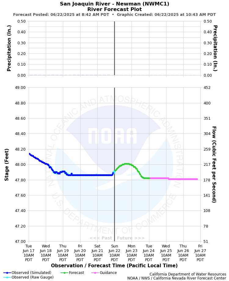
| SAN JOAQUIN RIVER - NEWMAN (NWMC1) | ||
| Latitude: 37.35º N | Longitude: 120.98º W | Elevation: 90 Feet |
| Location: Merced County in CA | ||
| River Group: San Joaquin | ||
| Forecast Issued: | Jun 22 2025 at 8:47 AM PDT | Next Issuance: | Jun 23 2025 at 9:00 AM PDT |
| Action/ Monitor: 63.0 Ft | Minor Flood: 69.4 Ft | Moderate Flood: 70.7 Ft | Major Flood: 71.7 Ft |
Prev. Point | Next Point | Tabular |
Back to Points | Back to Home | Ensemble Fcst |
 |
Historical Stage/Flow Data |
|||
|
Water Year
|
Peak Discharge (cfs)
|
Stage (feet)
|
Date
|
| Most Recent 5 Years | |||
2024* |
5,330 |
59.44 |
Mar 6, 2024 |
2023* |
19,800 |
65.93 |
Mar 17, 2023 |
2022* |
1,260 |
51.74 |
Dec 30, 2021 |
2021* |
1,760 |
53.26 |
Feb 1, 2021 |
2020* |
2,910 |
55.79 |
Oct 1, 2019 |
| Historical High Stage/Flow Events (Period of Record - Apr 1912 to Present) - Ranked by Flow | |||
1997* |
36,200 |
66.14 |
Jan 28, 1997 |
1938* |
33,000 |
-- |
Mar 07, 1938 |
1983* |
30,700 |
65.78 |
Mar 04, 1983 |
1969* |
28,000 |
65.90 |
Feb 26, 1969 |
2006* |
24,600 |
66.26 |
Apr 09, 2006 |
| * Discharge affected by regulation or diversion | |||
| Location Photographs | ||
| ESRI™ Locator Map |
| Flood Impacts | |
| 71.7 Feet | Top of levee rb |
| 70.4 Feet | Danger stage. |
| 70.0 Feet | Flood water reaches the top of the levee that surrounds the Newman waste water treatment plant. |
| 69.4 Feet | Project flood stage. |
| 66.26 Feet | Peak stage of record. 4/9/2006 |
| 66.14 Feet | 1/28/1997 |
| 65.0 Feet | The fisherman's bend trailer park north of hills ferry road begins to flood. |
| 64.0 Feet | The Wastewater Treatment Plant begins taking on river water and flood pumping begins. |
| 63.6 Feet | Sand slough will flow. |
| 63.0 Feet | Monitor stage. Levee patrols required. |
| 62.0 Feet | Water seepage begins outside the levee along the river, near the newman waste water treatment plant. |
| 55.0 Feet | The city of Newman Wastewater Treatment Plant (WWTP) begins to flood at the lowest point. Newman Police Department shooting range a the WWTP is also affected. |