Skip Navigation Linkswww.weather.gov 
NOAA logo - Click to go to the NOAA homepage National Weather Service   NWS logo - Click to go to the NWS homepage    
California Nevada River Forecast Center
navigation bar decoration      
MERCED RIVER - YOSEMITE AT POHONO BRIDGE (POHC1)
Latitude: 37.72º NLongitude: 119.67º WElevation: 3862 Feet
Location: Mariposa County in CaliforniaRiver Group: San Joaquin
Previous Forecast
Next Forecast
Previous Forecast
Sunday 04/29/2012 12-18 UTC
Tuesday 05/01/2012 12-18 UTC
Next Forecast
Selected Date: Monday 04/30/2012 12-18 UTC
Verification - Historical Graphical RVF
Month:  
Day:  
Year:  
Cycle:  
To view other verification locations, use our Historical Graphical River Forecast Interface
Location Photographs
Google™ Locator Map
Product Help

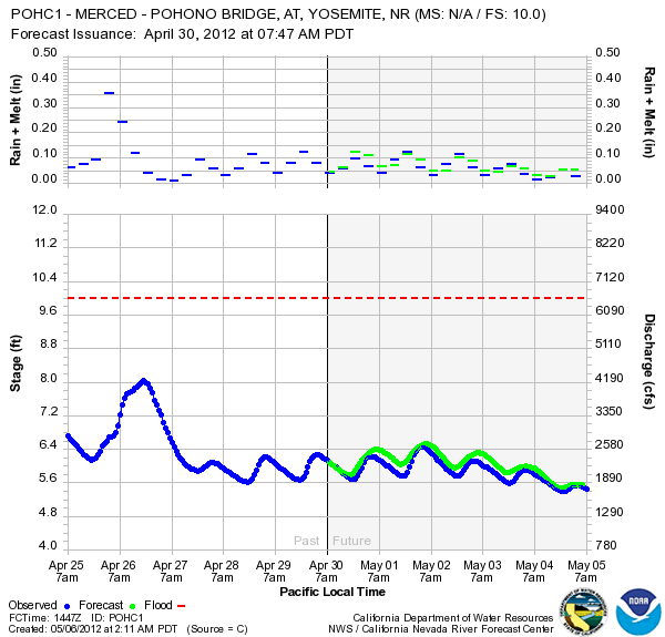
The historical graphical river forecast products display forecast and verified forecast hydrograph data. Included is a graphic display of the hydrologic input "Rain + Melt" that was used as input to the hydrological model (averaged for all upstream basins). [ Learn More About Results and the Interface ].


03

Webmaster
US Dept of Commerce
National Oceanic and Atmospheric Administration
National Weather Service
California-Nevada River Forecast Center
3310 El Camino Avenue, Room 227
Sacramento, CA 95821-6373

Tel: (916) 979-3056

Disclaimer
Information Quality
Credits
Glossary
Privacy Policy
Freedom of Information Act
About Our Organization
Career Opportunities