
| Back to Obs River Map | <<< Previous River Point | | | Next River Point >>> | Printer Version |
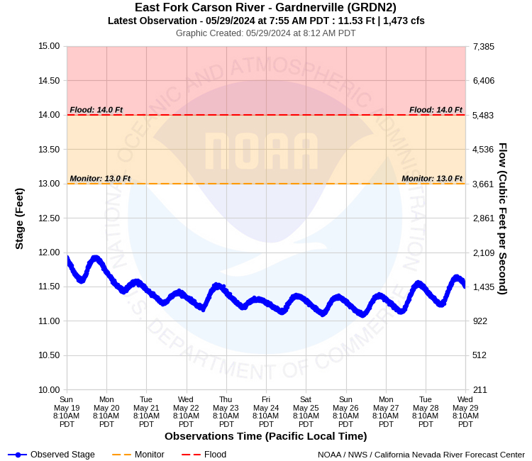
| Latitude: 38.85º N | Longitude: 119.70º W | Elevation: 4988 Feet | |
| Location: Douglas County in Nevada | River Group: Eastern Sierra | ||
| Monitor Stage: 13.0 Feet | Flood Stage: 14.0 Feet |
| Observed Data Credit | |
 | Raw streamflow data is provided by the US Geological Survey (USGS). |
Historical Stage/Flow Data |
|||
|
Water Year
|
Peak Discharge (cfs)
|
Stage (feet)
|
Date
|
| Most Recent 5 Years | |||
2022* |
3,530 |
12.82 |
Oct 25, 2021 |
2021* |
951 |
10.82 |
May 7, 2021 |
2020* |
1,530 | 11.36 |
Apr 30, 2020 |
2019* |
3,460 |
12.78 |
Jun 6, 2019 |
2018* |
5,850 |
14.21 |
Apr 7, 2018 |
| Historical High Stage/Flow Events (Period of Record - Discontinuous 1890 to Present) - Ranked by Flow | |||
1997* |
20,300 |
13.00*** |
Jan 2, 1997 |
1956* |
17,600 |
11.88*** |
Dec 23, 1955 |
1963* |
13,400 |
10.45*** |
Feb 1, 1963 |
1951* |
12,100 |
9.66*** |
Nov 21, 1950 |
| * Discharge affected to unknown degree by regulation or diversion | |||
| ** Prior to May 1939, several gage locations and datums within 2 miles of present location. | |||
| *** May 1939 to July 2001, gage location 300 ft downstream. Datum change with the difference +2.57 ft needing to be applied to all data in time range to convert to current datum. | |||
| **** July 2001 to January 2012, gage location 900 feet downstream with the same datum. | |||
| Location Photographs | ||
| ESRI™ Locator Map |
| Official 7 Day National Weather Service Forecast (NVZ003) |
| Rest of Today: Showers. Snow level 6500 feet. Snow accumulation up to 1 inch. Highs 54 to 64. Southwest winds 25 to 35 mph with gusts up to 60 mph. Tonight: Mostly cloudy with a chance of showers in the evening, then partly cloudy with a chance of snow showers after midnight. Snow accumulation up to 2 inches. Lows 28 to 33. Southwest winds 20 to 30 mph with gusts up to 55 mph. Sunday: Partly cloudy. Slight chance of snow showers in the morning. Highs 48 to 53. West winds 15 to 25 mph with gusts up to 45 mph. Sunday Night: Partly cloudy. Lows 29 to 34. West winds 15 to 25 mph decreasing to around 10 mph after midnight. Monday: Sunny. Highs 60 to 65. West winds 10 to 15 mph. Gusts up to 30 mph in the afternoon. Monday Night: Breezy. Clear in the evening then becoming partly cloudy. Lows 29 to 39. Tuesday through Wednesday Night: Clear. Highs 54 to 64. Lows 31 to 41. Thursday and Thursday Night: Clear. Highs 65 to 70. Lows 36 to 46. Friday: Sunny. Highs 70 to 75. |
| Impacts - E19 Information | |
| 13.0 Feet | Monitor stage. Near Bank full, no flooding occurring. Residents along the river should prepare for flooding if additional rises due to snowmelt and/or rainfall runoff occur. Flood prone areas include Washoe Tribe Reservation, Carson Valley Country Club, Glenwood Dr, Riverview Dr, Centerville Rd, NV Highway 88, Westwood Village, Rocky Slough, Dresslerville Rd, Waterloo and Mottsville Lanes. |
| 13.5 Feet | Lowest portions of Carson Valley begin to have flood threat. The most flood prone areas include the Washoe Tribe Reservation, Carson Valley Country Club, Glenwood Drive, Riverview Drive, Centerville Road, NV Hwy 88, Westwood Village, Rocky Slough, Dresslerville Road, Waterloo and Mottsville Lanes. |
| 14.0 Feet | Flood Stage. Minor lowland flooding in Carson Valley. Low-lying roads, bridges, and drainage structures begin to sustain minor damage. Cottonwood Slough begins to flood Lampe Park. Flood prone areas include Washoe Tribe Reservation, Carson Valley Country Club, Glenwood Dr, Riverview Dr., Centerville Ln., NV Highway 88, Westwood Village, Rocky Slough, Waterloo and Mottsville Lanes. Possible impacts to south bound Highway 395 lanes north of Stephanie Way. |
| 14.5 Feet | Minor flooding in Carson Valley with some outbuildings, roads, and bridges in lower portions of Minden, Gardnerville, Centerville, Washoe Tribe Reservation and Genoa flooded. Highway 395 lane closures north of Stephanie Way possible. |
| 15.0 Feet | Minor flooding in Carson Valley with some mobile home communities, outbuildings, many roads, and bridges in lower portions of Minden, Gardnerville, Centerville, Washoe Tribe Reservation and Genoa flooded. Lane closures on Highway 395 north of Stephanie Way likely. Similar level to 2/2017 flood. |
| 15.5 Feet | Moderate flood damage in Carson Valley area. Flooding starts to impact homes, businesses, schools, transportation, communication, and water and power systems. Closure of Highway 395 north of Stephanie Way likely. |
| 16.0 Feet | Moderate flood damage in Carson Valley. Some homes, business, schools, roads, and bridges in lower portions of Minden, Gardnerville, Centerville, Genoa, and Washoe Tribe Reservation flood. Moderate flood impacts to transportation, communication, and water and power systems. Highway 395 closure north of Stephanie Way likely. Flood level similar to January 2017 event. |
| 16.5 Feet | Major flooding in Carson Valley with significant damage. East Fork of Carson River feeds Rocky, Cottonwood, Martin, and Henninson Sloughs, which flood low portions of Minden/Gardnerville near downtown causing damage to homes, businesses, schools, roads, and bridges. Transportation, including prolonged impacts to Highway 395 north of Stephanie Way, communication, and water and power systems significantly affected. |
| 17.0 Feet | Major flooding in Carson valley with significant damage. The East Fork of the Carson River feeds Rocky, Cottonwood, Martin, and Henningson Sloughs which flood portions of Minden/Gardnerville near downtown, causing damage to homes, businesses, schools, roads, and bridges. Major effects to transportation, communication, and water and power systems. |
| 17.5 Feet | Major flooding in Carson valley with significant damage. The East Fork of the Carson River feeds Rocky, Cottonwood, Martin, and Henningson Sloughs which flood portions of Minden/Gardnerville downtown areas, causing damage to homes, businesses, schools, roads, and bridges. Major effects to transportation, communication, water and power systems. |
| 18.0 Feet | Widespread flood damage in Carson Valley. Extensive damage to homes, businesses, schools, roads, and bridges. Transportation, communications, water and power severely affected. Massive bank and channel erosion capable of sweeping away buildings, roads, and vehicles. |
| 18.5 Feet | Widespread flood damage in Carson Valley. Extensive damage to homes, businesses, schools, roads, and bridges. Transportation, communications, water and power severely affected. Potential for major bank and channel erosion capable of sweeping away buildings, roads, and vehicles. |
| 19.0 Feet | Widespread flood damage in Carson Valley. Extensive damage to homes, businesses, schools, roads, and bridges. Transportation, communications, water and power severely affected. Massive bank and channel erosion capable of sweeping away buildings, roads, and vehicles. |
| 19.5 Feet | Near Record Flooding. All roads in and out of Carson Valley flooded. Extensive damage to homes businesses, schools, roads, and bridges. Transportation, communications, water and power severely affected. Massive bank and channel erosion capable of sweeping away buildings, roads, and vehicles. Roughly similar to January 1997 event. |
| 20.0 Feet | Record Flooding. All roads in and out of Carson Valley flooded. Large portion of Carson Valley under water. Extensive damage to homes businesses, schools, roads, and bridges. Transportation, communications, water and power severely affected. Massive bank and channel erosion capable of sweeping away buildings, roads, and vehicles. Similar to, or in excess of, January 1997 event. |
| Product Disclaimer |
This river graphic is not intended to serve as a substitute for official flood watches, warnings, advisories, or statements issued by the NWS Reno Weather Forecast Office. Observations are preliminary and subject to change. River levels identified as "forecast" should be consistent with those contained in official NWS products. River levels identified as "guidance" have significant uncertainty due to future weather or reservoir regulation and are provided for planning purposes only. |