
| Back to Obs River Map | <<< Previous River Point | | | Next River Point >>> | Printer Version |
| Latitude: 39.63º N | Longitude: 119.28º W | Elevation: 4070 Feet | |
| Location: Washoe County in Nevada | River Group: Eastern Sierra | ||
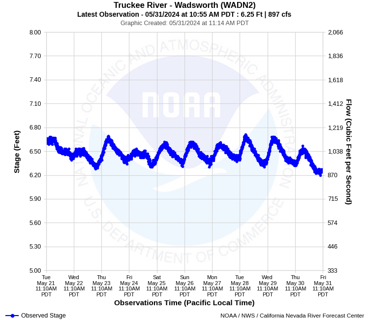
| Monitor Stage: 13.0 Feet | Flood Stage: 15.0 Feet |
| Observed Data Credit | |
 | Raw streamflow data is provided by the US Geological Survey (USGS). |
Historical Stage/Flow Data |
|||
|
Water Year
|
Peak Discharge (cfs)
|
Stage (feet)
|
Date
|
| Most Recent 5 Years | |||
2022* |
5,380 |
11.14 |
Oct 25, 2021 |
2021* |
487 |
5.18 |
Jun 4, 2021 |
2020* |
1,490 |
7.07 |
May 18, 2020 |
2019* |
6,670 |
12.38 |
Feb 14, 2019 |
2018* |
6,020 |
11.73 |
Apr 8, 2018 |
| Historical High Stage/Flow Events (Period of Record - Discontinuous 1965 - Present) - Ranked by Flow | |||
1997* |
19,100 |
19.64 |
Jan 3, 1997 |
1986* |
16,800 |
15.11** |
Feb 19, 1986 |
2006* |
14,800 |
16.89 |
Dec 31, 2005 |
2017* |
14,500 |
16.99 |
Jan 9, 2017 |
| * Discharge affected to unknown degree by regulation or diversion | |||
| ** Prior to September 1986, gage was located 0.5 mile downstream at a different datum. | |||
| Location Photographs | ||
| ESRI™ Locator Map |
| Official 7 Day National Weather Service Forecast (NVZ003) |
| Today: Partly cloudy in the morning then clearing. Highs 56 to 66. Northwest winds 10 to 15 mph. Tonight: Clear. Lows 30 to 35. North winds 10 to 15 mph. Wednesday: Sunny. Highs 58 to 63. Northeast winds 10 to 15 mph. Wednesday Night: Clear. Lows 36 to 41. Northeast winds 10 to 15 mph. Thursday: Sunny. Highs 67 to 72. East winds 10 to 15 mph. Thursday Night: Clear. Lows 39 to 49. Friday and Friday Night: Clear. Highs 74 to 79. Lows 43 to 53. Saturday through Sunday: Clear. Highs 80 to 85. Lows 46 to 56. Sunday Night: Partly cloudy. Lows 47 to 57. Monday: Sunny. Highs 80 to 85. |
| Impacts - E19 Information | |
| 13.0 Feet | Monitor stage. Very high flow, but no flooding between between Derby Dam and Nixon, river is near bank full in some areas. |
| 15.0 Feet | Flood stage. Minor flooding of agricultural lands along the river. |
| 17.0 Feet | Significant flooding of agricultural lands and some rural roads along the river. Water approaching some low lying homes near Wadsworth and Nixon. Access to several homes may be limited or closed. Similar to 1/9/2017 and 12/31/2005 peaks. |
| 19.0 Feet | Major flooding of agricultural lands and rural roads between Derby Dam and Nixon, including some structures in Wadsworth and Nixon. These areas include but not limited to Consetoga Ave, Quail Ave, and West Truckee River Ranch Road. |
| 20.0 Feet | Near record flooding. Extensive flooding of agricultural areas, roads, homes and infrastructure between Derby Dam and Nixon. Numerous homes impacted near Wadsworth. Slightly in excess of January 1997 peak. |
| Product Disclaimer |
This river graphic is not intended to serve as a substitute for official flood watches, warnings, advisories, or statements issued by the NWS Reno Weather Forecast Office. Observations are preliminary and subject to change. River levels identified as "forecast" should be consistent with those contained in official NWS products. River levels identified as "guidance" have significant uncertainty due to future weather or reservoir regulation and are provided for planning purposes only. |