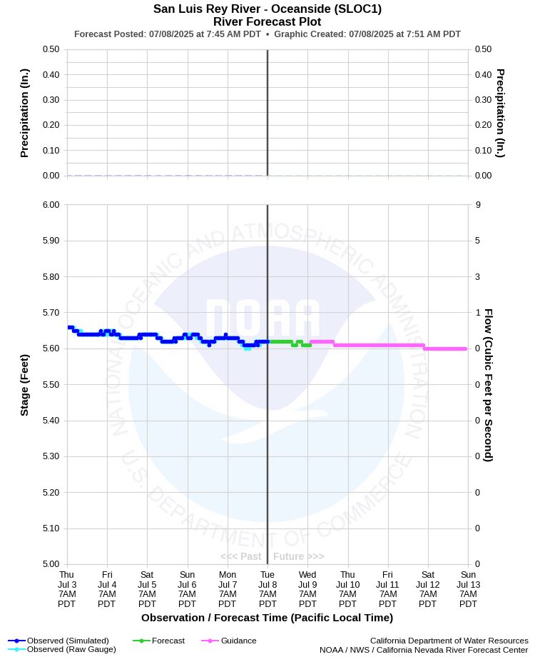
| SAN LUIS REY RIVER - OCEANSIDE (SLOC1) | ||
| Latitude: 33.22º N | Longitude: 117.36º W | Elevation: 20 Feet |
| Location: San Diego County in CA | ||
| River Group: Southern California | ||
| Forecast Issued: | Jul 07 2025 at 6:50 AM PDT | Next Issuance: | Jul 08 2025 at 9:00 AM PDT |
| Action/ Monitor: N/A | Minor Flood: 21.0 Ft | Moderate Flood: 24.5 Ft | Major Flood: 28.0 Ft |
Prev. Point | Next Point | Tabular |
Back to Points | Back to Home | Ensemble Fcst |
 |
Historical Stage/Flow Data |
|||
|
Water Year
|
Peak Discharge (cfs)
|
Stage (feet)
|
Date
|
| Most Recent 5 Years | |||
2024* |
1,080 |
9.36 |
Feb 6, 2024 |
2023* |
3,050 |
12.57 |
Mar 15, 2023 |
2022* |
66 |
6.71 |
Dec 26, 2021 |
2021* |
95 |
6.97 |
Jan 29, 2021 |
2020* |
5,520 |
16.18 |
Apr 11, 2020 |
| Historical High Stage/Flow Events (Period of Record - Oct 1946 to Present)*** - Ranked by Flow | |||
1916 |
95,600 |
-- |
Jan 27, 1916 |
1993** |
25,700 |
21.70 |
Jan 16, 1993 |
1980* |
25,000 |
14.00 |
Feb 21, 1980 |
2005* |
21,800 |
20.68 |
Jan 11, 2005 |
1995* |
19,500 |
19.97 |
Mar 06, 1995 |
| * Discharge affected by regulation or diversion | |||
| ** Maximum since regulation by Lake Henshaw | |||
| *** Most recent continuous record back to Oct 1946 with segmented periods back to Apr 1912 | |||
| **** No flow recorded during the entire water year | |||
| Location Photographs | ||
| ESRI™ Locator Map |
| Flood Impacts | |
| 28.0 Feet | Excess overflow of water has damaged some sewer and water mains in the city of oceanside. The lilac road bridge on the pala indian reservation has likely washed out. The rincon casino has been evacuated. Approaches to upstream crossings are likely damaged or washed out. North river road has likely been undermined in oceanside. The retainaing wall protecting homes in the rancho viejo project upstream from oceanside is likely compromised. Pala casino is at risk with possible evacuations. |
| 24.5 Feet | Extent of damage unknown. It is possible that the approaches to several of the upstream crossings will be damaged or washed out. The lilac road bridge on the pala indian reservation is likely impassable. Undermining of north river road in oceanside is possible. Undermining of the retaining wall protecting homes in the rancho viejo project is possible. Businesses in the flood plain not protected by the levee are at risk of innundation, including the pala casino parking areas and the rincon casino itself. |
| 21.0 Feet | Approaches to upstream bridges including camino del rey, shearer crossing, and couser canyon, among others, are threatened and possibly damaged. The lilac road bridge on the pala reservation is at risk. |
| 12.0 Feet | LOW-WATER CROSSINGS CAN BE IMPACTED WELL UPSTREAM OF THE GAGE BEFORE SIGNIFICANT GAGE RESPONSE OCCURS. GAGE HEIGHTS OF 9.5 TO 12 FT HAVE BEEN ASSOCIATED WITH THE CLOSING OF COLE GRADE ROAD AND LILAC ROADS. |