|
 |
||
 |
| HOME |
|
HAS QPF Process Mountain
Mapper
|
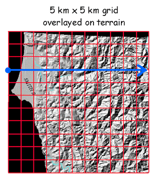
The Original Rhea Orographic Model The Rhea orographic aid is an adaptation of the original Rhea orographic model. The aid was developed because at the time of the original model development, computer access and processor speed were prohibitive to run the model routinely. However, the output of the original model was saved and forms the basis of the orographic aid in use today. It is helpful to understand the basic concepts of the original model in order to better understand the orographic aid. The original orographic model utilized a 5 km x 5 km grid overlayed on a map of terrain as shown in figure 1. The x-axis of the grid was aligned with downwind direction of the wind at 700 millibars.
Figure 1.
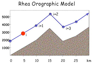
5 km x 5 km grid used in Rhea Orographic Model The model simulated the thermodynamic processes of air parcels forced vertically by the effects of terrain encountered while moving downwind along the x-axis. The model was multi-layer, using the midpoint of 50 mb increment layers between 1000 mb and 450 mb in its calculations. It was also described as steady state, meaning that the initial conditions did not change over the duration of the model run. The model contained no dynamics or explicit microphysics. Running the model would produce a precipitation estimate for each grid point. A single value precipitation estimate for an entire basin could be determined by simply averaging the precipitation estimates from all grid points located within the basin boundary. As the parcel in a particular layer moved along the x-axis of the grid in the downwind direction, it was forced upward (and downward) following the terrain as shown in Figure 2 below:
The assumptions made for each layer parcel as they were forced up or down by terrain included:
At the next grid point:
For sinking motion:
Layer Interaction:
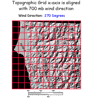
As mentioned earlier, the 5km x 5km grid was aligned with the 700 millibar wind direction, so the grid shifted over the terrain, as shown by figure 3. Changing the orientation of the grid altered the terrain along the path of the air parcels, resulting in different precipitation estimates for each grid point and ultimately for each basin.
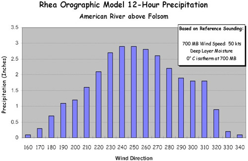
Figure 4 shows the strong correlation between 700 mb wind direction and rainfall in the American River basin above Folsom, known for its strong orographic influence on precipitation. In this case, the model was run several times using the same atmospheric conditions, but varying only the 700 mb wind direction by 10 degree increments. As one can see from the model output, the prime orographic 700mb wind direction for this particular basin lies between 240 and 250 degrees.
Figure 4. Rhea Orographic Model 12-hour QPF output for American River above Folsom |
|
National Weather Service California Nevada River Forecast Center 3310 El Camino Avenue, Room 227 Sacramento, CA 95821-6373 Phone: (916)-979-3056 Fax: (916)-979-3067 Page last modified: July 31, 2006 |