|
 |
||
 |
| HOME |
|
HAS QPF Process Mountain
Mapper
|
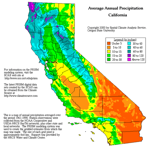
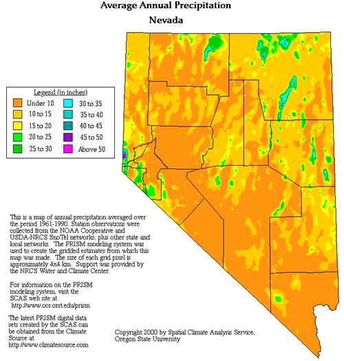
PRISM PRISM (Parameter-elevation Regressions on Independent Slopes Model) monthly precipitation is the gridded dataset used by Mountain Mapper software to distribute rainfall from a single QPF point to a gridded QPF field. A raster of 30-year average annual PRISM-derived precipitation is shown in Figures 1 and 2 below for California and Nevada, respectively. In these examples, it is easy to see the strong influence that topography exerts on the distribution of average annual precipitation.
Figure 1. PRISM Annual Average Precipitation - California
Figure 2: PRISM Annual Average Precipitation - Nevada PRISM is an expert system that uses point data and a digital elevation model (DEM) to generate gridded estimates of climate parameters. PRISM is well-suited to mountainous regions, because the effects of terrain on climate play a central role in the model's conceptual framework. It is called an expert system, because it attempts to mimic the process an expert would use to map climate parameters. PRISM uses digital elevation model (DEM) data on the 4 km x 4km grid interval and climatological precipitation records. The goal of PRISM is to derive a more complete and realistic climatological record of precipitation in mountainous terrain. The basic steps in the PRISM process include:
The precipitation data PRISM used to distribute precipitation consists of three basic climate datasets:
That's probably more than you ever wanted to know about PRISM, but if you want to know more, please refer to the Oregon Climate Service web site. |
|
National Weather Service California Nevada River Forecast Center 3310 El Camino Avenue, Room 227 Sacramento, CA 95821-6373 Phone: (916)-979-3056 Fax: (916)-979-3067 Page last modified: July 31, 2006 |