|
About CNRFC - Overview
The California-Nevada River Forecast Center (CNRFC) is a field office of the National Weather Service (NWS) located in Sacramento, California. The CNRFC is co-located with the Sacramento NWS Forecast Office, California Department of Water Resources, and United States Bureau of Reclamation. The NWS is an agency of the National Oceanic Atmospheric and Administration (NOAA) under the United States Department of Commerce. The mission of the NWS Water Resources Services Branch and National Water Center is to:
The NWS accomplishes its mission through 122 Weather Forecast Offices (WFOs), 13 River Forecast Centers (RFCs), and 9 National Centers for Environmental Prediction (NCEP). These field offices are administratively and technically supported by Regional and National headquarters. The NWS River Forecast Centers have four basic functions:
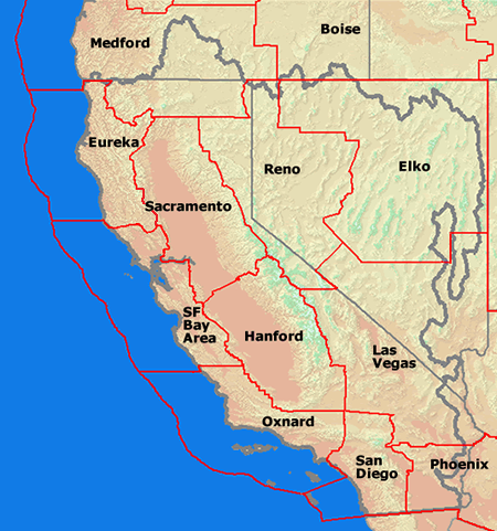
The hydrologic area of responsibility for the CNRFC is shown in Figure 1 above. This area, of approximately 250,000 square miles, exhibits extreme variation in hydrologic regimes, supports large population centers, and is highly environmentally sensitive. Extreme pressure is placed on the area's water resources. The 12 WFOs associated with this area are located in Medford OR, Eureka CA, Sacramento CA, Monterey CA, Hanford CA, Oxnard CA, San Diego CA, Reno NV, Elko NV, Las Vegas NV, Phoenix AZ, and Boise ID. The CNRFC is supported by and in turn supports these WFOs (Figure 2).
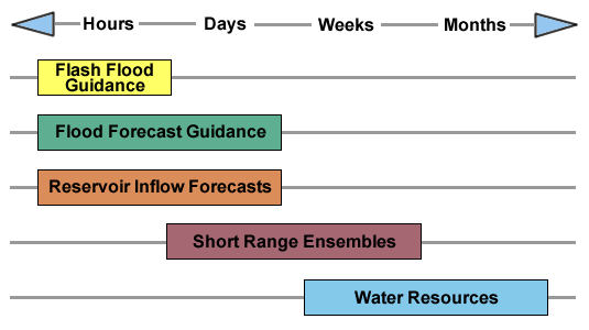
The CNRFC provides hydrologic guidance for time scales that vary from hours (flash flood guidance, flood forecasts, and reservoir inflows), to days (flood forecasts, reservoir inflows, and short-range ensembles), to weeks (short-range ensembles and water resources), to months (water resources) as shown in Figure 3 below.
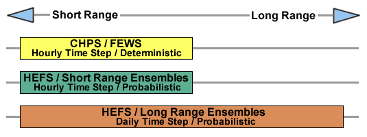
To develop this guidance the CNRFC employs a host of hydrologic models and procedures that range from simple to complex and empirical to process simulation (Figure 4).
The CNRFC is firmly committed to providing the best possible river forecast guidance to its customers. Improvements come in the form of expanded coverage and increased quality. Efforts are continuously underway to improve the process used to forecast flooding and water resources. |
|||||||