


Total gages: Control-click to temporarily remove an icon Show cursor readout Include elevation readout Valid: Created: LOADING....  NO SIGNIFICANT RIVER FLOODING IS EXPECTED IN THE CNRFC FORECAST AREA Forecast (large dots): The number inside each circle above represents the number of gages with observed conditions inside that category. The number inside each circle above represents the number of gages with forecast conditions inside that category. The number inside each circle above/below represents the number of gages with conditions inside that category. Observed (small dots): The number inside each circle above represents the number of gages with observed conditions inside that category. The number inside each circle above represents the number of gages with forecast conditions inside that category. The number inside each circle above/below represents the number of gages with conditions inside that category.
|
Rivers/ReservoirsWater ResourcesSnow DataObserved Precipitation (QPE)Forecast Precipitation (QPF)Observed TemperaturesForecast TemperaturesFreezing LevelsFlash Flood Guidance/Debris FlowWater TemperaturesClimate/DroughtQPF VerificationWatches/Warnings/Advisories
| ||||||||||||||||||||||||||||||||||||||||||||||||||||||||||||||||||||||||||||||
|
Note 1 About Product: |
This product contains provisional data from automated gages and has not been screened or verified for accuracy. |
|
Note 2 About Product: |
Some river and reservoir gages may be hidden at zoomed out levels of the map due to a large amount of data being represented. Zoom closer to view all relevant data in specific area of interest. |
|
Note 3 About Product: |
The location of the river or reservoir gage is represented by the bottom-left corner of the icon. |
|
Alternate Text Product: |
|
|
Feedback / Comments: |
Email the CNRFC Webmaster with your feedback and comments. |
|
Note 1 About Product: |
This product is updated daily with current water year forecasts plotted. |
|
|
Note 2 About Product: |
Most recent Official or Raw ESP Water Supply Forecast during the current water year is plotted. |
|
|
Alternate Text Products: |
|
|
|
Feedback / Comments: |
Email the CNRFC Webmaster with your feedback and comments. |
|
|
Note 1 About Product: |
This product contains provisional data from automated gages and has not been screened or verified for accuracy. |
|
Note 2 About Product: |
Some snow water equivalent gages may be hidden at zoomed out levels of the map due to a large amount of data being represented. Zoom closer to view all relevant data in specific area of interest. |
|
Alternate Text Product: |
CNRFC Snow Water Equivalent Summary | CNRFC Snow Depth Summary |
|
Feedback / Comments: |
Email the CNRFC Webmaster with your feedback and comments. |
|
Note 1 About Product: |
This product contains provisional data from automated gages and has not been screened or verified for accuracy. |
|
Note 2 About Product: |
Some precipitation gages may be hidden at zoomed out levels of the map due to a large amount of data being represented. Zoom closer to view all relevant data in specific area of interest. |
|
Alternate Text Product: |
|
|
Feedback / Comments: |
Email the CNRFC Webmaster with your feedback and comments. |
|
Alternate Text Products: |
Basin QPF Days 1-3 | Basin QPF Days 4-6 | Point QPF Days 1-3 | Point QPF Days 4-6 |
|
Feedback / Comments: |
Email the CNRFC Webmaster with your feedback and comments. |
|
Note 1 About Product: |
This product contains provisional data from automated gages and has not been screened or verified for accuracy. |
|
Note 2 About Product: |
Some temperature gages may be hidden at zoomed out levels of the map due to a large amount of data being represented. Zoom closer to view all relevant data in specific area of interest. |
|
Alternate Text Product: |
|
|
Feedback / Comments: |
Email the CNRFC Webmaster with your feedback and comments. |
|
Alternate Text Products: |
US Drought Monitor Data | CPC 6-10 Day and 8-14 Outlook Discussion | CPC Long-Lead Seasonal Outlook Discussion |
|
Feedback / Comments: |
Email the CNRFC Webmaster with your feedback and comments. |
|
Feedback / Comments: |
Email the CNRFC Webmaster with your feedback and comments. |
|
Note: |
Please select a data type above to activate KML download section. |
|
|
Feedback / Comments: |
Email the CNRFC Webmaster with your feedback and comments. |
|
US Dept of Commerce
National Oceanic and Atmospheric Administration
National Weather Service
California Nevada River Forecast Center
3310 El Camino Avenue, Room 227
Sacramento, CA 95821-6373
(916) 979-3056
Comments? Questions? Please Contact Us.
This image is currently not available. Please try again later.
The selected data is currently not available. Please check again later.
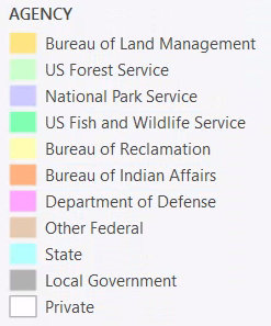
 Topography |  Topography/USGS |  ESRI Topography |  Shaded Relief |  Imagery |
 Nat'l Geographic |  Topo/Rivers |  Topo/Hydro |  Light Gray | 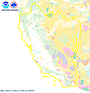 Federal Lands |
The "Download PNG" feature is not available in this browser. Please try a different browser.
Load a point data set to view data.